A gray mare, a bay mare, four sheep, twenty hogs, corn standing in the fields, and two beds with their furniture: in August 1833, Anthony Forehand pledged these things as security for rent owed on a place called Johnnycake Town. The land was not his. What he could offer Demsey Grandy, the man to whom the rent was due, was the livestock, the growing crop and the household goods named in the mortgage.1
Two years earlier the debt had belonged to two brothers. Anthony and William Forehand had agreed in February 1831 to pay fifty dollars for a year’s rent of Grandy’s place. When Anthony made the mortgage on 1 August 1833, William was dead. Anthony had also undertaken another fifty-dollar obligation for the same place that year. The document puts these obligations beside the belongings he pledged, bringing the business of renting a farm into the household itself.1
The clerk had no need to explain where Johnnycake Town was. The name was sufficient for the people conducting this business. To recover something of their neighborhood, we can begin with a crossroads that a traveler can still recognize.
The opening beyond Ivy Neck
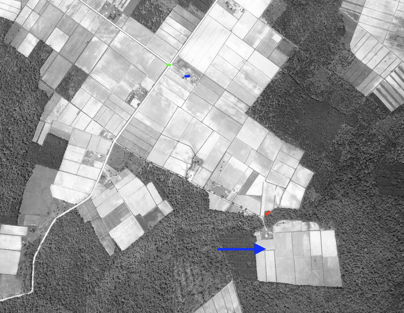
Local knowledge places the stop at the meeting of Belcross Road and Ivy Neck Road, matching the location described in Jesse Forbes Pugh’s 1953 driving tour of Camden County. Pugh had come through Indiantown and along the old road toward Plank Bridge. Here, in the vicinity called Ivy Neck, he stopped at the road leading right, two miles to Belcross. Looking southwestward, to the left from that point on his route, the traveler could see a distant opening. Johnnycake Town also appears as Johnnykin Town, the name Jesse Forbes Pugh used in his 1953 tour. The variation may reflect local pronunciation, though we have not established how it arose.1012
A grave and an old house gave Pugh more to tell. He associated Johnnykin Town with Thomas Nickols and said that his grave marker could still be seen. He also described an ancient residence about three hundred yards west, on a plantation called The Yaupons. The starting point of that measurement was not explicit. The Yaupons, the Nichols plantation of the deeds and Anthony’s rented farm therefore remain distinct leads; a familiar neighborhood name does not make them one property.12
Local knowledge places the Johnnycake Town locality east of Ivy Neck Road, south of Belcross Road, near McKimmey Road and Mercer Drive. The Nichols graves are reported beside the eastward spur. The markings on the aerial photograph below supply the modern reader with the crossroads, opening and burial place that make the old account easier to follow. These are approximate local identifications, not the surveyed bounds of the nineteenth-century farms.10
Where the roads met the water
Before the automobile made such a tour possible, a Camden journey often depended on a landing as much as a road. Thalia T. Jones, writing about colonial Albemarle, describes people traveling by boat to conduct business and visit friends. Cypress canoes and flat-bottomed scows served shallow creeks; sloops and shallops used the larger waters. A creek that interrupted a road could also provide another way into the country.11
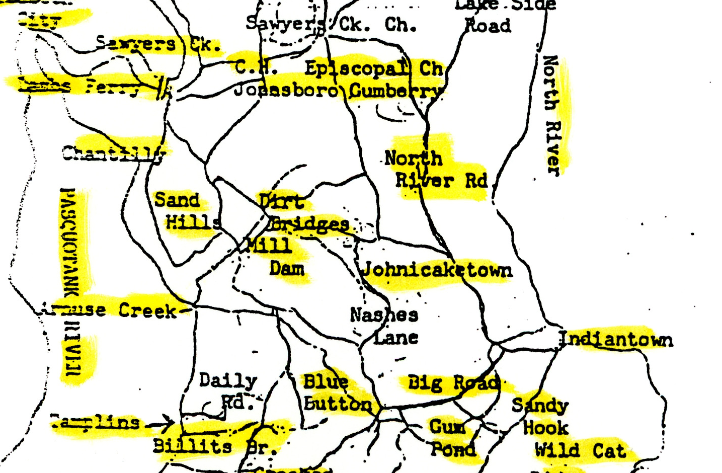
Keeping the roads open was a continuing obligation. Jones recounts a 1704 order requiring residents on the route from Store Landing on Arenuse Creek to Indiantown Causeway to keep it passable. A separate, undated presentment complained about neglect of the road between Pascotank and Coratuck by the Indian Town House. Such records concern the practical matter behind every line on a map: whether people could get through.11
The Nichols deeds bring that country into closer view. In September 1778, Coston and Rhoda Sawyer sold Thomas Nichols about fourteen acres described by a branch of Mill Swamp, Sawyer’s house and a footbridge. Later conveyances under Nichols’s name refer to the easternmost branch of Aranuse Creek, Hickory Branch, the road to Indiantown and the road from Plank Bridge toward Indian Town. These were separate parcels. Taken as descriptions of a neighborhood, however, they show how a house, a branch and a crossing could locate a piece of land for people who knew the way.5
By the years before the Civil War, corn was Camden’s chief crop, according to Pugh. He describes sailboats loading it along Raymond’s, Arenuse, Sawyers and Joy’s creeks for overseas markets. Anthony’s own destination for his crop is unknown, but his mortgage gives corn a very definite place in the farm’s finances. Still standing in the fields, it was already pledged against the rent.19
Corn also belonged to the hearth, and the name Johnnycake Town naturally invites a question about the bread. The period recipes considered here describe a cornmeal cake, with variations in ingredients and preparation. In American Cookery in 1796, Amelia Simmons called hers “Johny Cake, or Hoe Cake.” She directed the cook to combine Indian meal—cornmeal—with scalded milk and a little flour, then bake it before the fire. An alternative added salt, molasses and shortening. This was a practical way to turn ground corn into bread using the heat of the household fire.13
A southern recipe gives us a particularly useful glimpse of the work. The 1855 edition of The Carolina Housewife, published under the name “A Lady of Charleston,” mixed cold hominy with butter or lard, an egg, milk and corn flour. The cook spread it a quarter-inch thick on a board before the fire, then passed a thread underneath to loosen it for transfer and browning on the other side. These recipes help us understand the food the place-name calls to mind. Neither establishes what the Forehands ate, or why this Camden neighborhood acquired its name. That origin remains unresolved.14
The families behind the name
The Nichols burial ground carries us back before Anthony’s tenancy. Thomas’s stone records his death in June 1799, in his seventieth year. Deborah’s identifies her as his wife; George’s identifies him as Thomas’s son, without naming his mother. An explicit record connecting the Thomas buried here to the landowner in the earlier deeds has not yet been found. Even with that question open, the inscriptions preserve relationships that the changing names in a deed book can easily obscure.4
The documents under the Nichols name also preserve the presence of enslaved people. A Thomas Nichols household in the 1790 census contained three free white people and nine enslaved people; its identity with the Thomas buried here remains provisional. The census named only the household head. A sale recorded three years earlier supplies one young person’s name: Easter. On 12 June 1787, Thomas Nichols, described as a planter, sold her to Denny Sawyer for ninety pounds. She was about fourteen. We cannot yet follow her family or later life, or place her among the nine people counted in 1790. Her name and age survive because the law recorded her sale.7
By December 1837, four years after Anthony pledged his mares and household goods, a tract of about two hundred acres in Jonicake Town passed from John D. Grandy to Tully Dozier. Dozier sold it to Abner H. Grandy in March 1839, when it was described as the Nichols plantation. Dempsey Grandy had appeared as an adjoining owner in the earlier transaction. His neighboring ownership is a reason to keep Anthony’s rented place separate from this two-hundred-acre tract unless another record connects them.23
The next transaction brings Martha Grandy into the story. On 14 May 1839, her husband Abner conveyed fifty acres from the tract to John L. Ferrell, who conveyed them to Martha on the same day. The twelve hundred dollars used for the purchase had come from the sale of her own land to Isaac Sanderlain, with Abner’s consent. The sequence is worth following: beneath the succession of names, the deed identifies the source of Martha’s purchase money and the land acquired for her.3
In November 1858, another arrangement joined land and family. Evelina Dozier, then living in Virginia, conveyed a hundred and forty acres to her niece Evelina Palmer for ten dollars and natural love and affection, reserving an interest during her own lifetime. The tract adjoined Martha Grandy and Elizabeth Nash, though its connection to the earlier two hundred acres is still unsettled. Johnnycake Town continued to serve as a place people could name when providing for a relative or describing a boundary.8
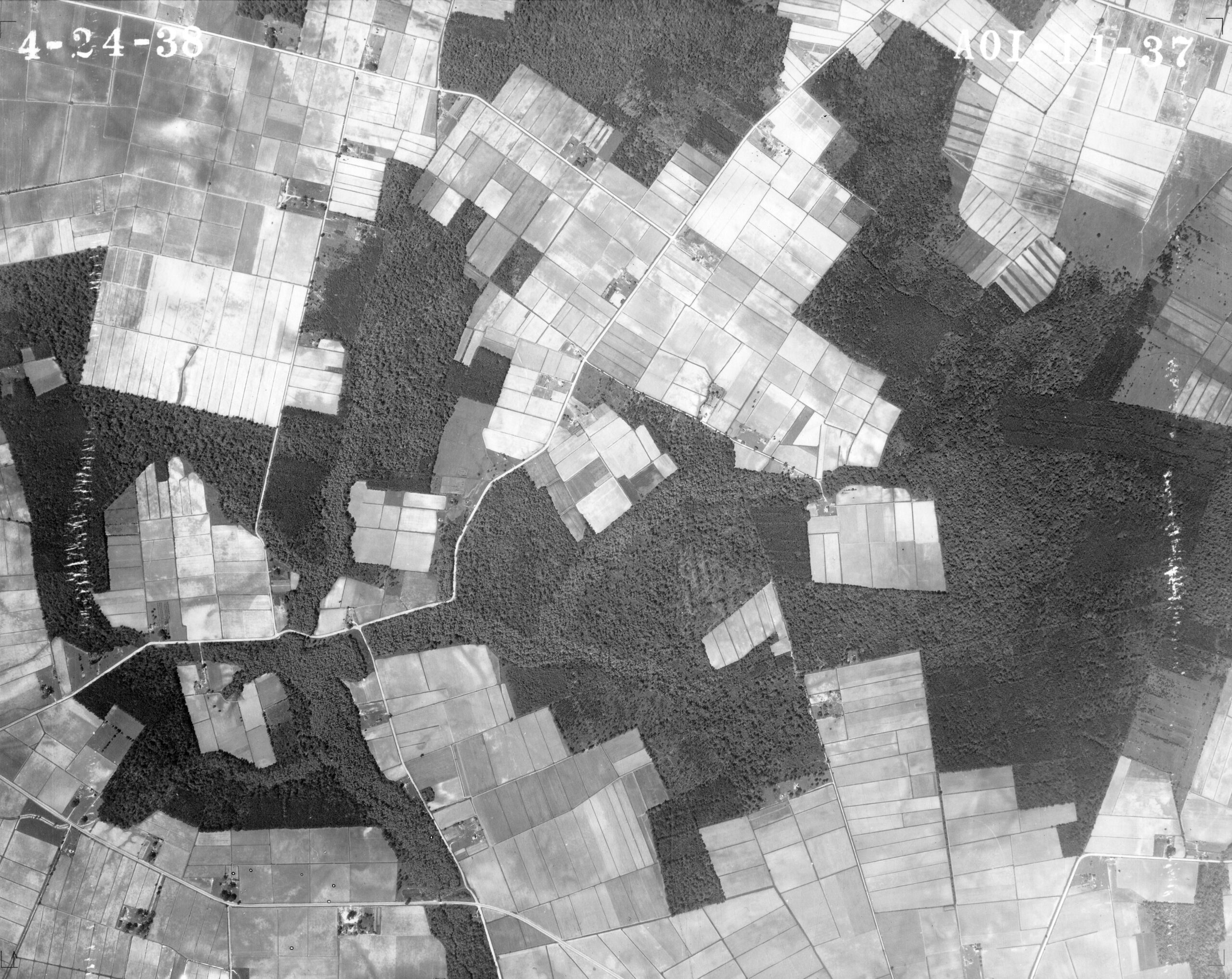
The opening Pugh pointed out in 1953, the fields on the 1938 aerial and the locally identified graves allow us to return to this neighborhood with more than a name. They do not recover every farm boundary or explain every change of ownership. The documents bring us closer to particular lives: Martha’s land money, Evelina’s provision for her niece, Easter’s recorded sale, and Anthony’s obligation after his brother’s death.13781012
For Anthony, the surviving mortgage ends before we learn how the rent was settled. It does tell us what stood behind his promise to pay. Return to the list with which we began: the gray mare and the bay, the sheep and hogs, corn not yet harvested, and two beds with their furniture. In the county books, Johnnycake Town could be measured in hundreds of acres. In Anthony Forehand’s agreement, it reached as far as the things he needed to keep a household and work a farm.1
Sources and further reading
Anthony Forehand mortgage to Demsey Grandy, executed 1 August 1833, proved 20 August, registered 21 August 1833; Camden County, North Carolina, Deed Book U:251; FamilySearch DGS007513208, image141. Record viewer · Saved full spread (held in the research collection). County recorded-copy image; source B03. The mortgage uses Wm. for the brother's given name.
John D. Grandy to Tully Dozier, executed 13 December 1837, acknowledged May Term 1838, registered 15 June 1838; Camden register p.217; DGS007513208, image423. Record viewer · Saved full spread (held in the research collection). County recorded-copy image; B11.
Tully Dozier to Abner H. Grandy, 12 March 1839; Abner H. Grandy to John L. Ferrell, 14 May 1839; Ferrell to Martha Grandy, 14 May 1839. Camden register pp.303–304; DGS007513208, image468. Registered 16 June, 16 June and 18 June 1839 respectively. Record viewer · Saved full spread (held in the research collection). County recorded-copy images; B05. The plantation surname ending is difficult; the research reading is Nichol[as/es].
Nichols Cemetery photographs and geographic leads, source F17, in the family source guide (held in the research collection) and photo provenance (held in the research collection), acquired 14 October 2026. Thomas, Deborah and George inscriptions were compared with older local photographs. Exact disputed inscription digits are withheld here. Contributed cemetery location and the earlier contributed geographic account are orientation leads, not a boundary survey. Modern orientation: NCDOT, Camden County, North Carolina, four-sheet county map set, information updated September 2026, sheets 1 and 3 visually inspected 27 October 2026; official PDF. Camden County Comprehensive Transportation Plan, 2010 AADT and Study Road Network, complete map visually inspected 27 October 2026, identifies North River Road SR1135 and North Trotman Road SR1121. Modern orientation verification and saved official maps are recorded in the 27 October geography audit (held in the research collection).
Coston and Rhoda Sawyer to Thomas Nichols, executed 14 September 1778, acknowledged September Term, registered 11 June 1779, Camden register pp.123–124; DGS007513200, images73–74 (first page, continuation); Thomas Nichols to David Gregory, 10 February 1785, p.239, image339 (viewer); Nichols to Elijah Sawyer, 9 March 1785, pp.266–267, image353 (viewer). County recorded-copy images, B09–B10/B08/B07; full copies in the source catalog (held in the research collection).
North Carolina, 1783 act, chapter XXXVII, State Records of North Carolina, vol.24, pp.529–530. UNC transcription · Saved printed laws (held in the research collection). Printed compilation/transcription, A02; the prior investigation inspected the decisive printed pages. The act concerns assurance of title to Isaac Guilford for 35 acres called Shergolds.
Original 1790 federal census, North Carolina vol.2, Camden p.265, division allotted to Edmund Blount, NARA M637 roll7 (viewer, saved manuscript spread (held in the research collection)), F22. Thomas Nichols to Denny/Denney Sawyer, executed 12 June 1787, acknowledged September Term, registered 4 December 1787; Camden D:205, DGS007513201 image116 (viewer, saved spread (held in the research collection)), B22. Original census manuscript image and county recorded-copy sale instrument respectively.
Evelina Dozier to niece Evelina Palmer, 2 November 1858, proved 3 November, registered 8 December 1858; Camden register p.85, DGS007513210 image343 (viewer, saved spread (held in the research collection)), B15. Later spelling evidence includes the 16 June 1858 Grandy–Etheridge conveyance, p.47, image324, B19, and the 11 December 1866 Palmer–Morrisett deed, pp.462–463, image535, B16; see the catalog (held in the research collection). All are county recorded-copy images. The historical spellings do not prove the name's origin.
Jesse Forbes Pugh, Three Hundred Years Along the Pasquotank: A Biographical History of Camden County (Old Trap, North Carolina, copyright1957), p.141; source list for the Cornelius Gray Lamb sketch,p.230 (not a sentence-specific source attribution). ECU catalog · Inspected printed pp140–141 (held in the research collection) · Reference guide and full book (held in the research collection). Secondary1957regional history; this paragraph's exact wording was separately checked against the printed image in the image/argument review (held in the research collection).
Contributed local knowledge identified the Belcross Road–Ivy Neck Road intersection on 28 October 2026; the 27 October marked aerial (held in the research collection) identifies Pugh’s intersection in green. This modern alignment is attributed local knowledge; Pugh calls it the road leading right two miles to Belcross in the vicinity of Ivy Neck. An annotated satellite screenshot supplied 27 October 2026 identifies the general Johnnycake Town area (red square) and Nichols graves (green circle); original photography date unknown. Official NC OneMap road centerlines confirm the modern street names. This attributed location does not establish historic property bounds. See the historical map reference guide (held in the research collection) and unchanged screenshot, official road data, dated map sources and separate review (held in the research collection). This specific locator supersedes the earlier North River/Trotman regional orientation, whose original source scope remains preserved in note4 and the prior draft.
Thalia T. Jones, ‘Transportation in Colonial Days,’ in Camden County Historical Society, Book Committee, Historical Highlights of Camden County 1777–1977 (Elizabeth City: Carolina Printing Company, cataloged1977), pp12–14; DigitalNC record238097, Camden County Heritage Museum copy. Printed p12: travel, craft and the reported1704 road (held in the research collection) · Printed p13: road presentment (held in the research collection) · Printed p14: undated endorsement and source (held in the research collection). Secondary1977 account of earlier colonial travel; not an eyewitness description of Anthony’s1833 tenancy. The reported1704 road order has not been inspected as an original. The separate presentment is explicitly ‘Without date’ and cites J.R.B.Hathaway, North Carolina Historical and Genealogical Register, vol3 no2 p227; neither that original nor a modern alignment was established in this revision. Craft and travel details provide regional context, not Anthony’s itinerary. Full reading and separate page check (held in the research collection).
Jesse Forbes Pugh, Journeys Through Camden County (Camden, March1953), printedp10,3.5-mile stop. Original scanned page (held in the research collection). Secondary local history; owner, builder, distance origin and connection to the deed-defined tracts remain unresolved. Evidence and search coverage (held in the research collection) · Independent paragraph review (held in the research collection).
Amelia Simmons, American Cookery (Hartford: Hudson & Goodwin, 1796), p. 34, “Johny Cake, or Hoe Cake.” Library of Congress scan, PDF page 38. Printed recipe image inspected 28 October 2026; complete PDF and page image preserved in the research collection. A historical recipe, not evidence of a particular Camden household’s meal or the town name’s origin.
A Lady of Charleston, House and Home; or, The Carolina Housewife, third edition, corrected and enlarged (Charleston: John Russell, 1855), p. 26, “Corn Journey or Johnny Cake.” Library of Congress scan, PDF page 32. Printed recipe and edition title page inspected 28 October 2026; complete PDF and page image preserved in the research collection. This is the inspected 1855 edition, not a claim that the 1847 first edition was examined.