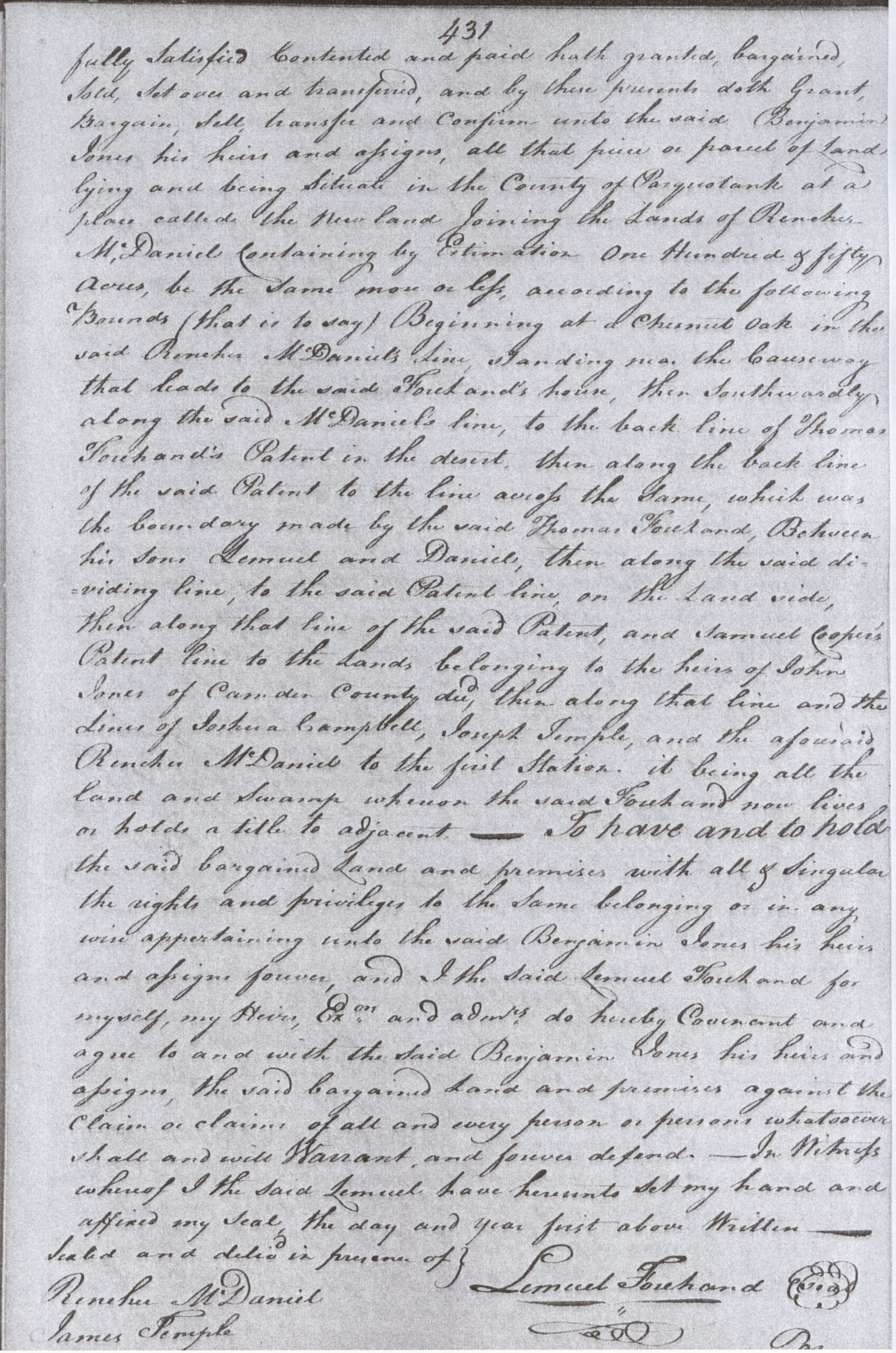
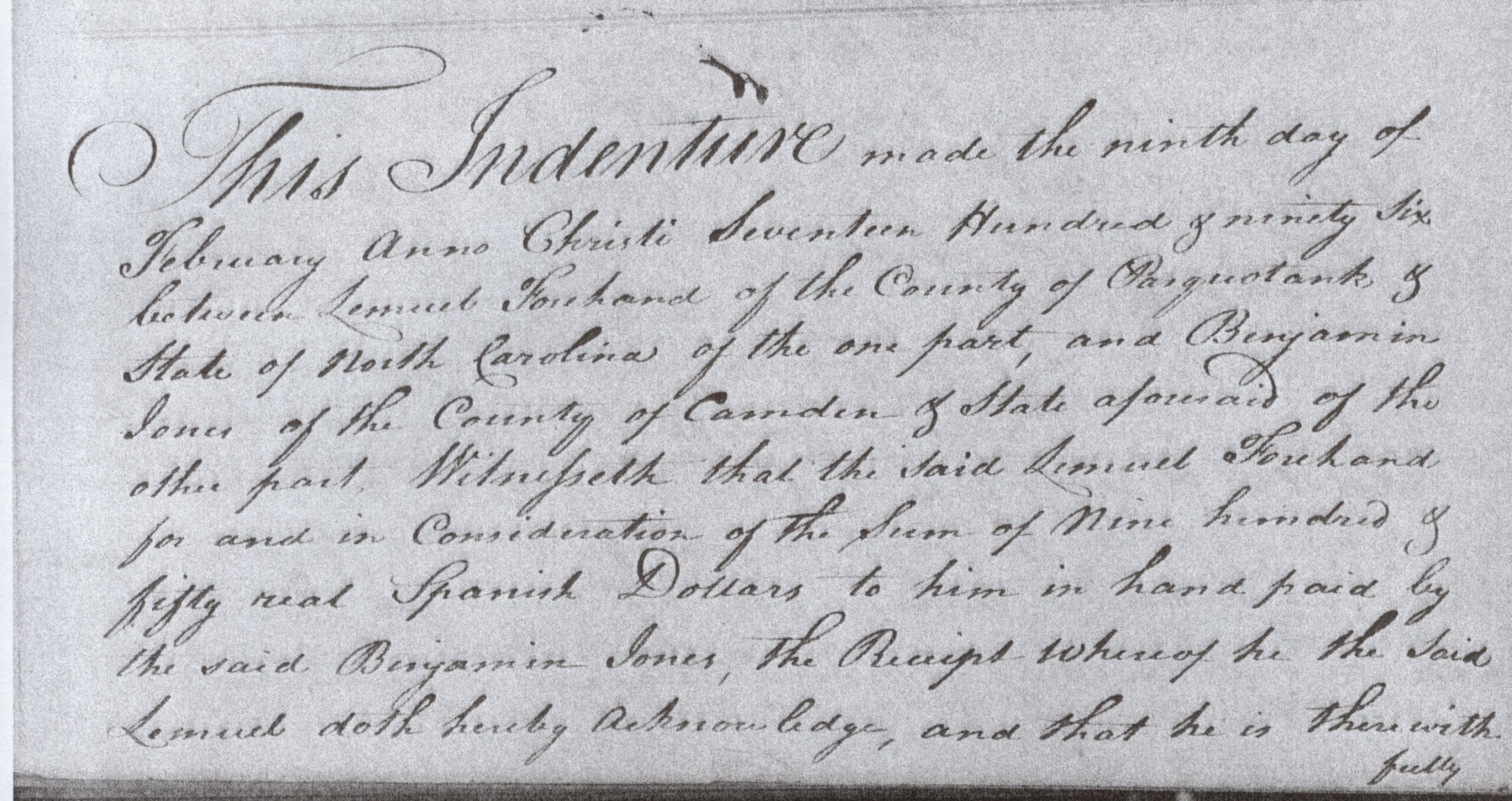
In February 1796, a deed at Newland began at a chestnut oak near the causeway to a Forehand house, reached the back line of Thomas Forehand’s patent, and then took up an older division. Thomas had been dead for more than twenty-six years. His son Lemuel was selling 150 acres to Benjamin Jones, yet the description still depended on a line Thomas had made between Lemuel and Daniel. The wording preserved both the boundary and the relationship:
“the boundary made by the said Thomas Forehand Between his Sons Lemuel and Daniel”
That sentence, in a transaction made long after Thomas’s death, is one of the clearest accounts we have of his family. LR07
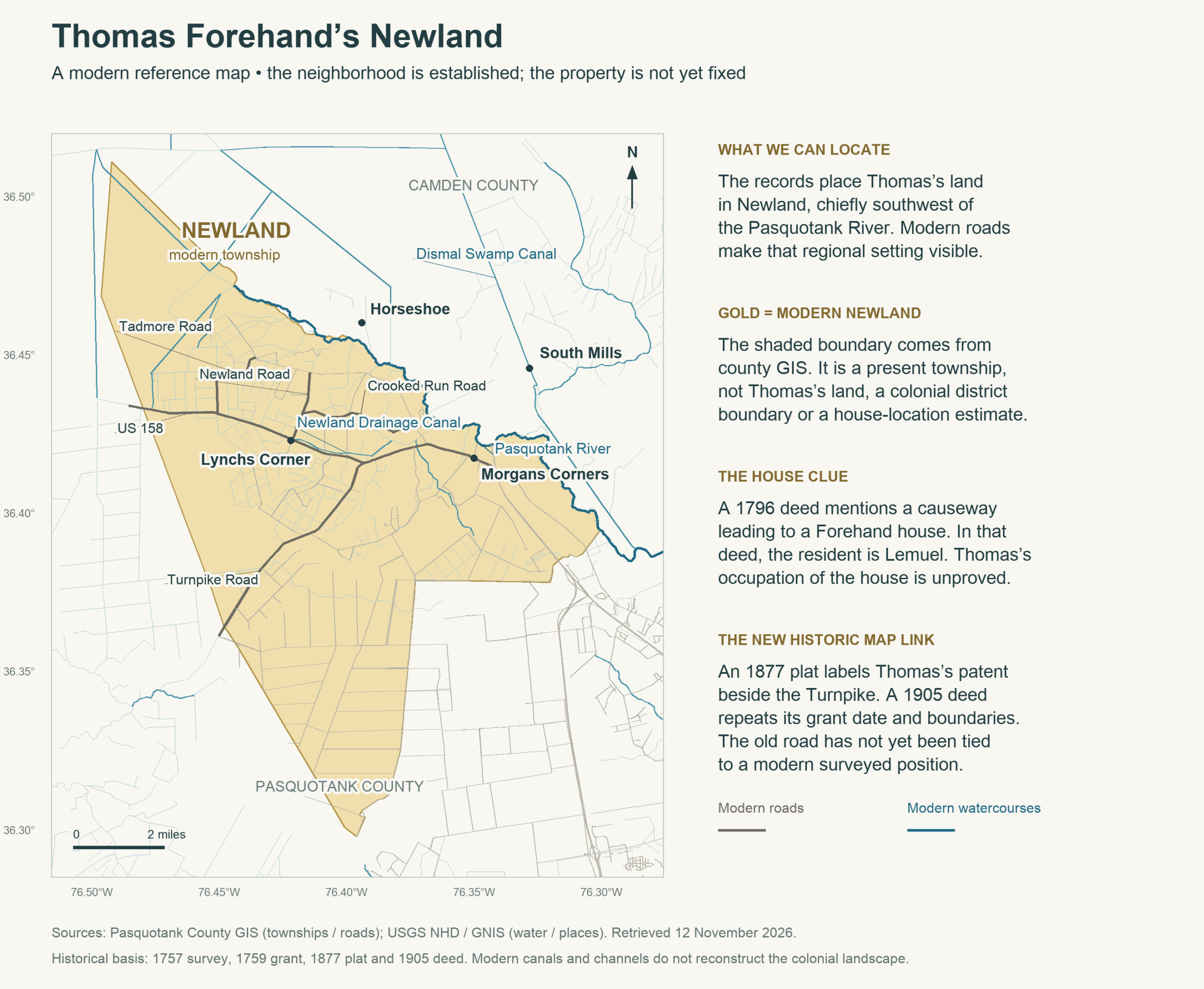
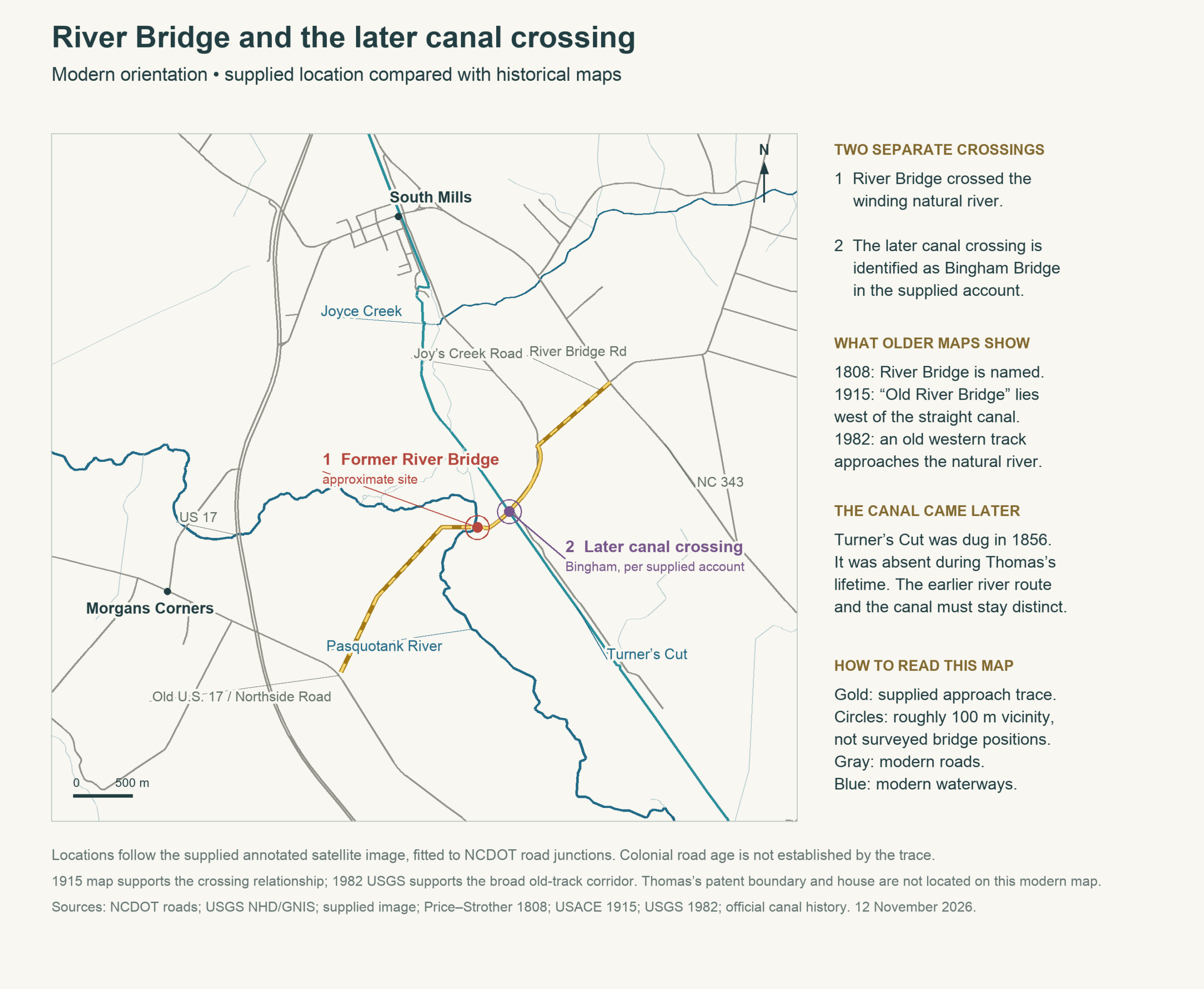
Newland was Thomas’s neighborhood toward the upper Pasquotank River, chiefly on its southwest side. His deeds belong among its fields, swamp land and adjoining claims. We can now place his 535-acre patent within a later mapped holding called Hinton Turnpike Farm, beside the adjoining 1791 patent and the historic Turnpike. The modern map below gives that country a recognizable setting; its gold boundary marks today’s Newland township, not Thomas’s land. R01 RB1 RB2 RB5
At the river, another old name helps connect this landscape with the Camden side: River Bridge. The 1808 map places it east of the Hinton and Turnpike area. A century later, an Army Corps of Engineers map still marked “Old River Bridge” on the winding Pasquotank, with an approach from the southwest. That crossing belongs in our picture of the roads leading toward Newland, although no record examined here describes Thomas making the journey. RB3
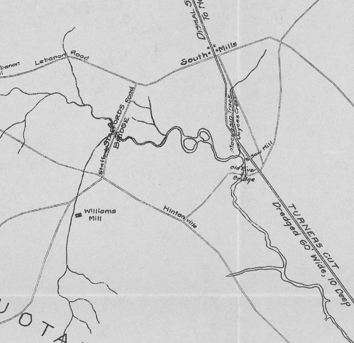
The straight channel beside it came later. Turner’s Cut was dug in 1856, long after Thomas’s death, and the 1915 map shows the old natural-river crossing west of the cut and a separate crossing over the canal. The vanished River Bridge and its approaches have also been located approximately through supplied local knowledge, checked against modern roads and the older maps. On the Pasquotank side, the marked approach leads toward the old U.S. 17 alignment; on the Camden side it follows the River Bridge and Joys Creek road corridor toward NC 343. That comparison restores the broad connection across the river without fixing a colonial road centerline or a corner of Thomas’s patent. RB3 RB4 RB5
An earlier Thomas appears in Cornelius Forehand’s will of 24 February 1727/8. Cornelius left his “well beloved son Thomas Forehand” two cows. This son was very likely the man who later held land at Newland: the local family setting and chronology fit, and no competing contemporary Thomas has been identified in the checked records. The will supplies neither his age nor a description of the later property. Two cows are the whole of Thomas’s specifically named legacy in that instrument. LR01
The Newland man comes into clearer view in the tax returns. On 7 June 1740, Thomas was charged for two white taxable persons. Two years later, a South-parish return charged him for one. The unnamed second person in 1740 cannot be made into a particular son or other member of his household. Thomas’s own birth date is unknown. If the 1740 entry includes his own ordinary tax liability, it supports birth by 1724; it does not supply an exact birth year. LR15 LR16 DATES
Land purchases give the next part of his story. In August 1743, Owen Reese conveyed him 52½ acres at Newland, part of a larger tract on the southwest side of the Pasquotank. The consideration was £10 in fresh pork—a value stated in the deed, not ten pounds’ weight. Thomas was described as a planter. Over the following years he acquired other pieces of land and sold some of his holdings, leaving a record of transactions with other Newland landholders. LR08 LR09 LR10 LR11 LR12
A surviving plan shows the 535 acres surveyed for Thomas on 25 April 1757. Its uneven outline follows neighboring claims, including Owen Reese’s. The Granville deed followed on 17 January 1759, naming Thomas as a planter in St. John’s Parish and the land as Newland. The survey and grant agree on 535 acres. Later copies and descriptions give conflicting numbers, but these two records preserve the acreage of this particular grant. It should not be taken as a measurement of everything Thomas owned. R01
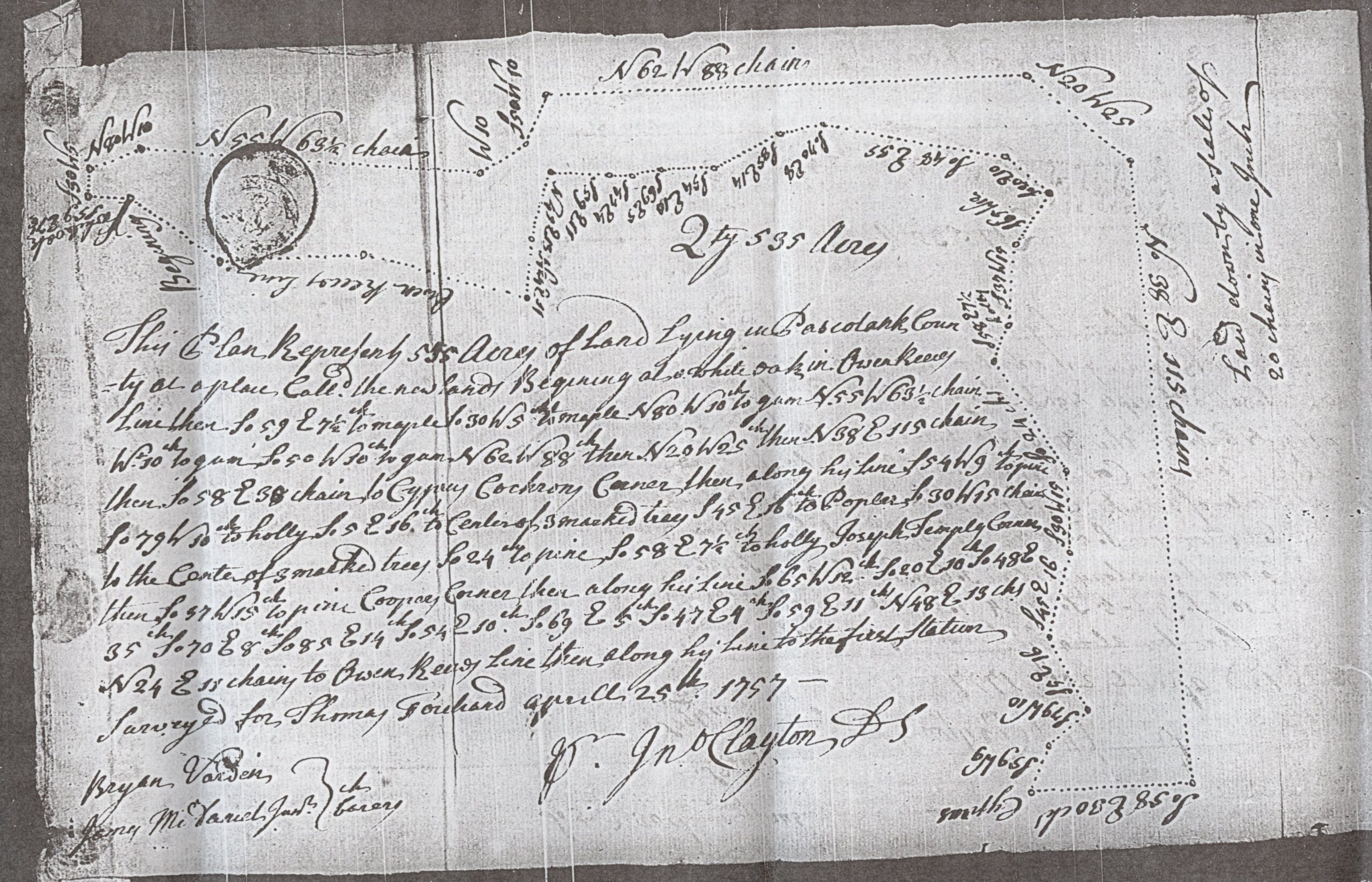
Thomas’s name remained on the landscape long after the land left his hands. An attached plat in a Pasquotank deed of 1877 labels “Thomas Forehand’s Patent,” gives its 535 acres and the date 17 January 1759, and draws it beside the adjoining 1791 patent and Turnpike Road. A timber deed of 1905 repeats Thomas’s grant date and boundary description. It also places the beginning of that adjoining patent at a cypress stump in Thomas’s line on the Old Turnpike Road. Together, these records carry the colonial patent into a recognizable later farm layout. RB1 RB2
Examine the complete 1877 deed and patent plat (Pasquotank Book WW, pages 68–69; archive sign-in may be required).
The old plan needs to be read on its own terms: south is at the top, north at the bottom. Its dwelling-house symbol belongs to the later farm depiction, with no evidence identifying it as Thomas’s home. The 1796 causeway points instead toward Lemuel’s house, the residence described while Lemuel was selling land. The patent’s place within that later holding is established; its corners still need to be tied to fixed points on the ground. LR07 RB1
The search is now focused on southern Turnpike Road, around Lynchs Corner and Mill Pond and the adjoining Campground and Sexton road network. The 1905 soil map and aerial photographs dated 8 March 1938 show roads and cleared-field edges that can be compared with the old plan. Some spacing is similar, but directions and farther junctions do not line up closely enough to fix the patent. This is a narrower area for comparison: neither Thomas’s parcel boundaries nor his house has been located on modern ground. RB6 RB7
The difficulty was already apparent to timber buyers more than a century ago. In April 1909, two civil engineers sent to plan logging roads located the patents and found much of the Forehand land occupied and claimed by others. A return visit on 3 August exposed the earlier mistake: the buyers’ estimator had examined only a small strip along the patent’s southern edge and chiefly timber on neighboring swamp outside it. Much of the land actually within the patent was arable, rather than the timber country the buyers had expected. The printed court opinion of 1911 preserves that distinction. The engineers’ drawing has not been recovered, and the plat supplied for the earlier inspection has not been identified as the 1877 plan. T03
A militia list associated with 1755 places a corporal called “Thos. Forehom” in William Abercrombie’s company. He was probably Thomas Forehand. The entry adds a likely public duty to the land and tax record, though it supplies no account of a battle or expedition. Thomas’s known life ended in 1769, before the Revolution; any wartime experiences of the next generation belong to their own stories. LR20 LR02
In September 1769 he made two conveyances that have drawn particular attention. On the seventh he sold David Forehand sixty acres for £45 proclamation money. Two days later he conveyed another sixty acres to Lemuel for £20. Lemuel and Joseph Spence witnessed David’s purchase; David and Joseph Spence witnessed Lemuel’s. The two Forehands later gave evidence for one another’s deeds in court. The records place these men together around Thomas’s last known land transactions, but say nothing about an illness or a plan to settle his affairs before death. R05
By December Thomas was dead. His inventory is dated 7 December in the preferred reading. On the fifteenth, Lemuel entered an administration bond for the estate. The £800 written in that bond was the amount of the penal security, not a valuation of Thomas’s estate. Lemuel later presented the inventory on oath at the March 1770 court. LR02
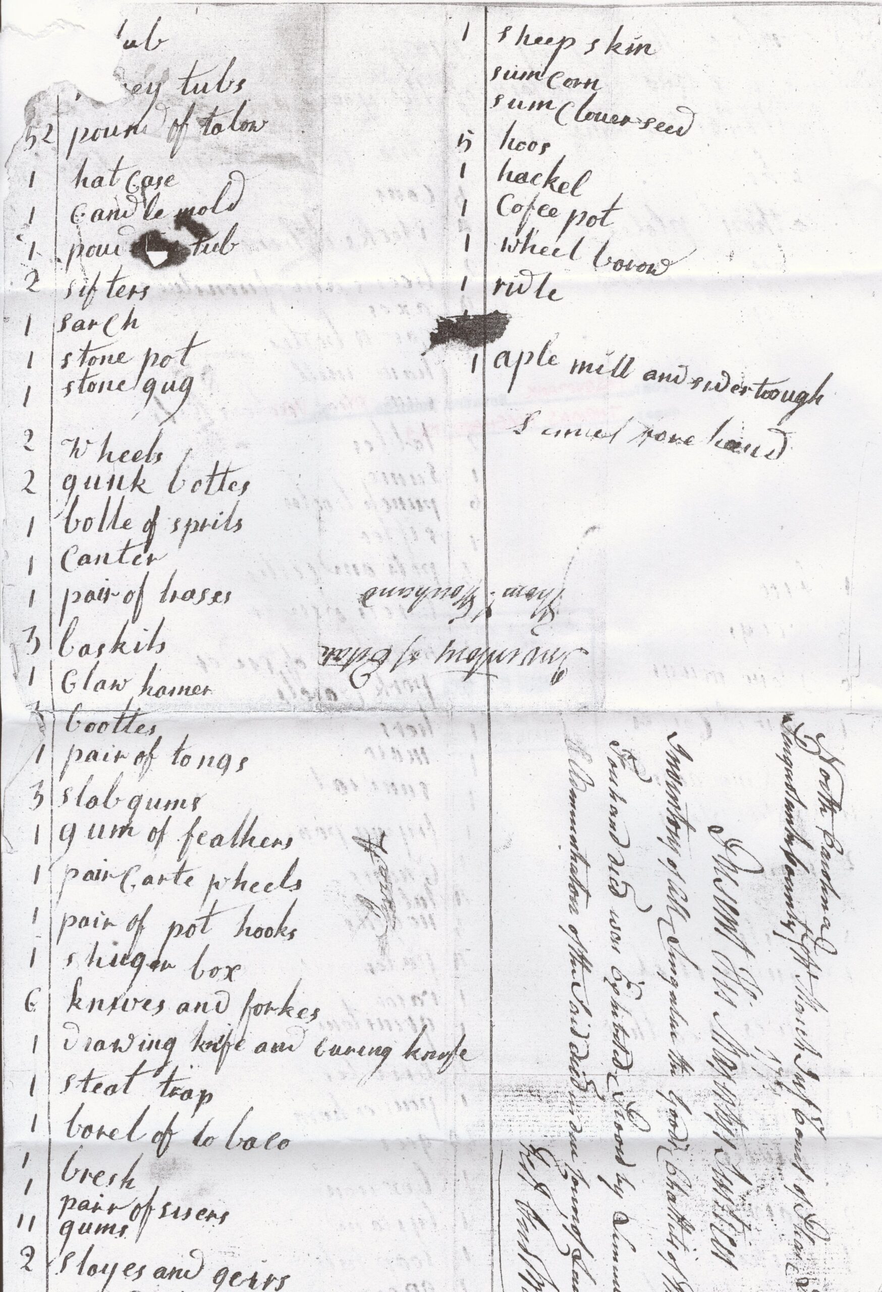
The inventory brings the household into view more closely than the land deeds do. Alongside cattle, hogs and geese were plows, a loom, spinning wheels, hides and leather, and shoemakers’ tools. The account also listed books, pewter, a gun, an apple mill and cider trough. These were the goods the estate had to account for. They suggest several kinds of work carried on around the household without telling us who performed each task. We have no wife’s name beside them, no account of who read the books, and no list that identifies all the children. LR02
The land continued to change hands. Lemuel sold Daniel two hundred acres in October 1772. After Daniel’s death, his executor conveyed 150 acres at Newland in 1783, reciting its descent from Thomas to Lemuel and then its conveyance to Daniel. By the time Lemuel made the 1796 sale, his father’s boundary still had a practical purpose: it helped describe the property a new owner was buying. Thomas’s place in the family survives most plainly in that old line between two sons. LR05 LR06 LR07
Family Ties
Cornelius is very likely Thomas’s father. His 1727/8 will expressly names a son Thomas, and the local chronology and family evidence strongly support identifying that son with the later Newland man. This is a High confidence inference, distinct from the will’s direct statement. If the identification is right, the other children in that will—John, Cornelius, James, Richard, Elizabeth and a daughter conventionally read as Mary—were his siblings. Cornelius named a wife Elizabeth, but did not expressly say she was Thomas’s mother. LR01
Thomas’s wife remains unknown. The tradition that he married Sarah Everton was repeated in the Ross/Baker family manuscript revised in 1998, which cited Joel, or Jody, Forehand’s website. That citation traces the claim’s transmission, not a contemporary marriage record or the reasoning behind it. Sarah is therefore not named as Thomas’s wife or as the mother of his sons here. Nor do the records establish that the sons all shared one mother. ECU-M1
Three sons are directly documented, through two explicit relationship records. A tax return attributed to 1769 reads:
“Forehand Thomas & sons Jarvis & Daniel”
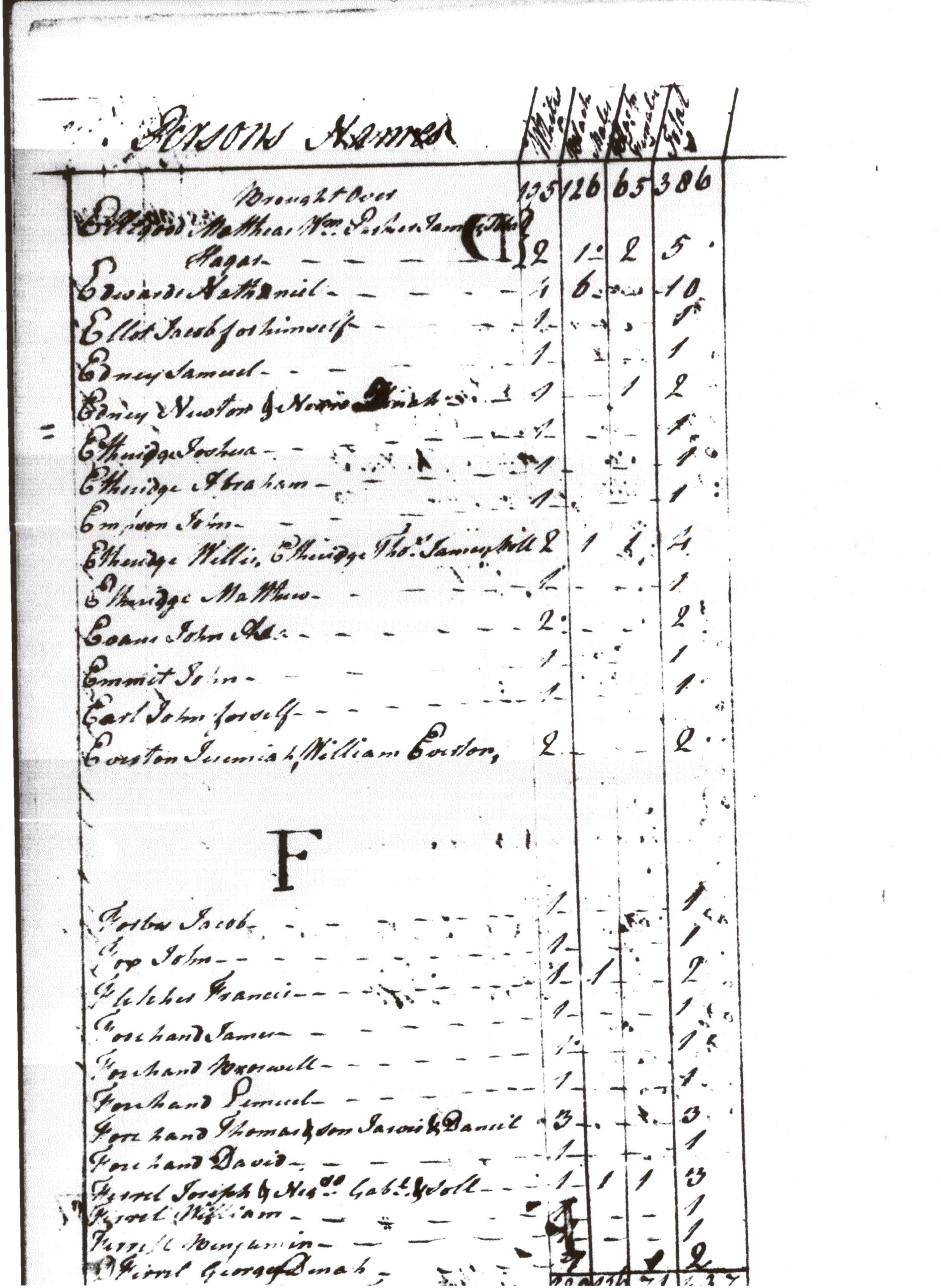
The line accounts for three white taxables, though the year is not visible in the surviving view. The 1796 deed supplies the other explicit relationship statement:
“the boundary made by the said Thomas Forehand Between his Sons Lemuel and Daniel”
Together these records document three sons:
- Lemuel: The 1796 deed expressly calls him Thomas’s son. The separate 1783 recital describes him as Thomas’s heir at law; the 1769 estate names him administrator. The latter records support the family reconstruction but do not themselves say “eldest son.” LR07 LR06 LR02
- Daniel: Both the tax return attributed to 1769 and the 1796 boundary recital expressly call him Thomas’s son. These are two direct statements in different records. LR19 LR07
- Jarvis: The tax return expressly names him as Thomas’s son alongside Daniel. Its exact year remains an attribution, and the later Chowan identification remains a separate question. LR19
These are all the direct sonship clauses currently identified in the records examined for this family.
There is further evidence for Lemuel’s position. The 1783 deed made by Daniel’s executor, Ezekiel Hollowell, says Thomas’s land descended to Lemuel as his heir at law, and that Lemuel conveyed it to Daniel. Together with the explicit sonship, this supports the qualified interpretation that Lemuel was probably the eldest surviving eligible son. It does not prove he was Thomas’s firstborn child. His appointment as administrator is a separate fact, not itself evidence of birth order. LR06 H-law LR02
The 1772 transfer from Lemuel to Daniel also belongs in the family’s evidence, but it does not call them brothers. Their relationship rests on the explicit sonship records. Likewise, identifying the Jarvis in Thomas’s tax entry with the later Chowan man, or identifying Daniel with the Perquimans testator, requires comparison of their later records. A name in the sons clause does not automatically absorb every later record of that name. These three documented sons are a minimum, not a complete census of Thomas’s children. LR05 LR06 LR19
Between the Lines
Possibilities, not proven relationships
David has the strongest presently identified case for investigation as an additional son. The September deeds put him beside a documented son, Lemuel, in two sixty-acre transactions only two days apart, with reciprocal witnesses and the same third man, Joseph Spence. David also belongs to the local Forehand tax and militia circle. On the militia face associated with a 1766 endorsement, Lemuel is a corporal and David appears among the men, along with James and Jarvis. These connections give the hypothesis substance. R05 LR18 LR21
The differences matter just as much. Neither September deed calls David a son. His £45 consideration is the same amount stated in Thomas’s 1764 purchase of an apparently corresponding tract. It is a purchase on the face of the record, not a demonstrated gift. Lemuel’s £20 deed describes land from a different parent tract: 443 acres rather than David’s 503. Equal acreage does not prove equal value, equal treatment or a shared inheritance. Even the proposed link to Thomas’s 1764 purchase retains a directional conflict: that earlier deed says southwest of the river, whereas David’s says northwest. R03 R05
Read the two September 1769 conveyances
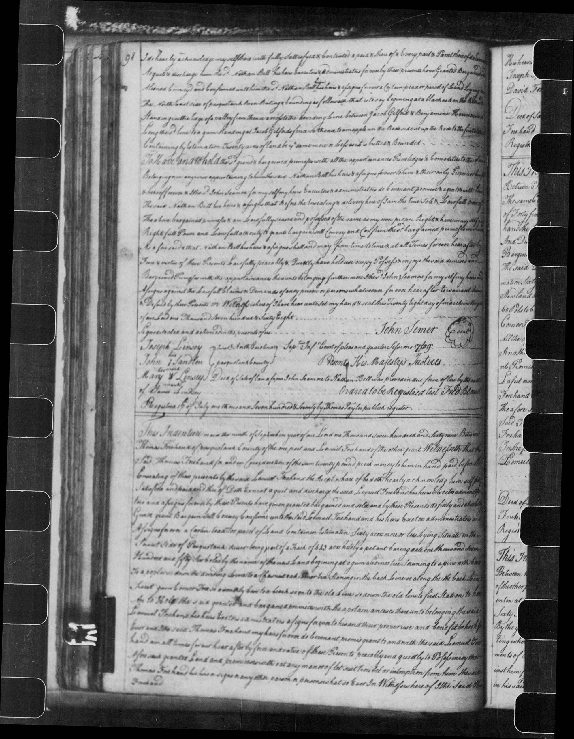
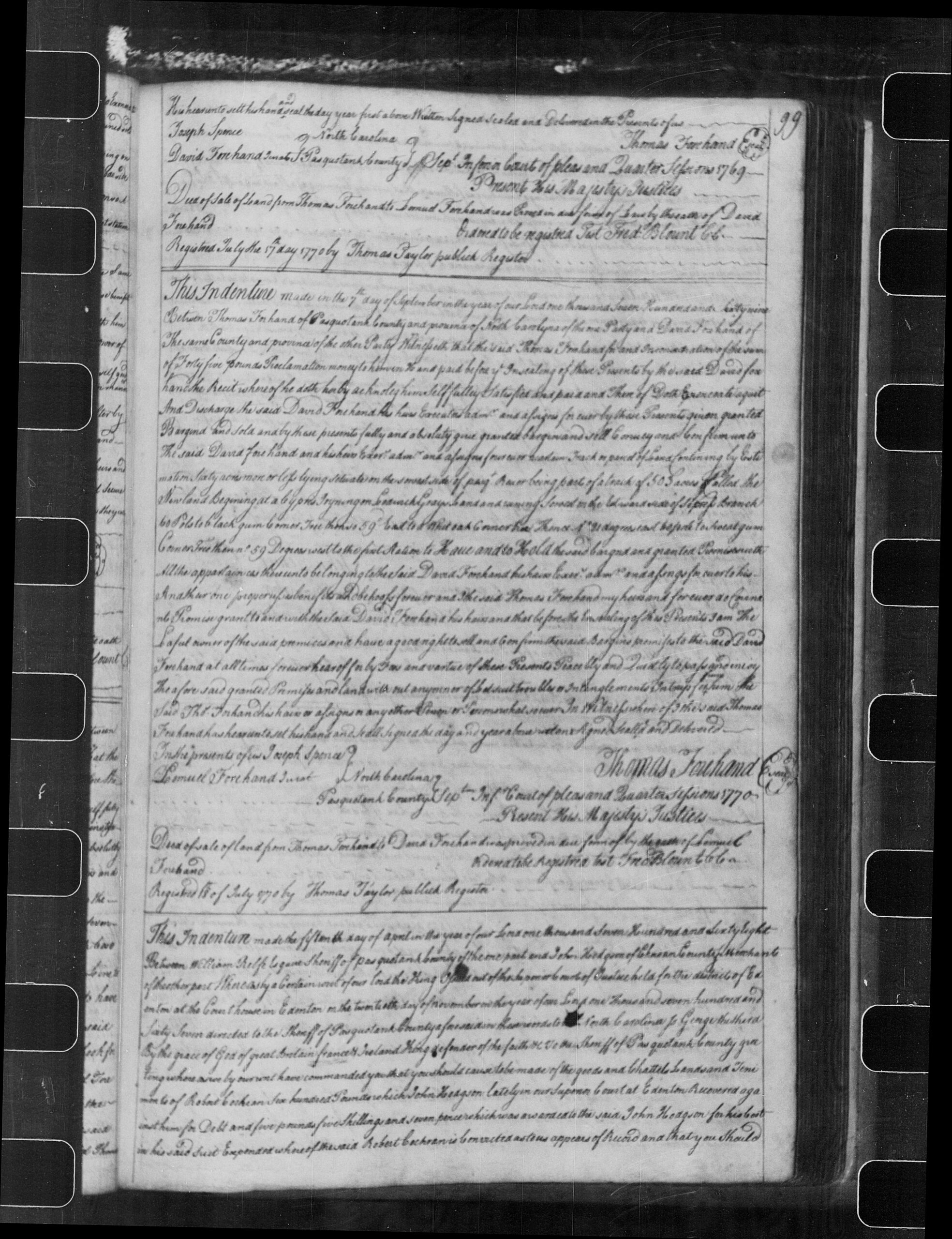
The tax evidence also has limits. David’s separate entry does not prove that he was twenty-one, maintained a separate house or was Thomas’s child. An alphabetical run of Forehand names is not a map of related households. A brother, nephew, another relative or an unrelated buyer with close local connections could fit the known transactions. Until a record supplies the relationship, possible son is the appropriate description. LR18 LR19 DATES
There is another question beyond it: was this Pasquotank David the David who made a will in Guilford County in 1802? Very likely: witnesses named Jordan Forehand recur in the coastal and Guilford deeds, and the compatible chronology supports High confidence in the identification. Whether the witnesses were the same man is itself part of the comparison. This strong identification does not establish Thomas as David’s father or make the Guilford family Thomas’s descendants. A later deed tracing the Newland land through named relatives, or an estate division naming Thomas’s heirs, would be much more decisive than another appearance of the surname. DAVID
Other Forehands deserve attention without being added to Thomas’s children. Elijah witnessed the 1772 sale between Lemuel and Daniel, but was not called their brother. James appears in the militia material without a child-specific clause; more than one generation of the name must be distinguished. John’s early tax appearances likewise supply no statement that he was Thomas’s son. These associations are worth preserving. They do not yet justify additional branches on the tree. LR05 LR14 LR15 LR18 LR21
A Life in the Records
This is the presently identified record inventory, not an exhaustive county search. Attributed dates, later copies and unresolved identities are labeled; proof and registration do not create a new living appearance.
Lifetime records and attributed appearances
| Date | Record |
|---|---|
| 24 February 1727/8 | Cornelius’s will gives his named son Thomas two cows. This son is identified with Newland Thomas with High confidence; the link is inferred. [LR01] |
| Attributed 1739 | A tax photograph lists Thomas with one taxable. No dated heading is visible; the county fragment is a different sheet. [LR14] |
| 7 June 1740 | Thomas’s return includes two white taxable persons. The additional person is unnamed and is not identified as a son. [LR15] |
| 10 June 1742 | A dated South-parish return lists Thomas with one white taxable and none in the black-taxable column. [LR16] |
| 19 August 1743 | Owen Reese conveys 52½ acres in Newland, southwest of the Pasquotank River, to Thomas for £10 payable in fresh pork. Acknowledged October 1743; registered 22 November 1743; surviving copy dated 20 November 1819. [LR08] |
| Attributed 1754 | Thomas appears with one taxable in a selected crop whose dated heading is missing. [LR17] |
| Attributed 1755 | The corporal written “Thos. Forehom” in William Abercrombie’s militia company is probably Thomas Forehand. The local photographs lack a date heading; enrollment does not prove combat service. [LR20] |
| 25 April 1757 | A survey for Thomas describes 535 acres. Its actual date differs from the photograph’s 1759 filename. [R01] |
| 25 March 1758 | James McDaniel conveys 60 acres in Newland to Thomas for £20 proclamation money, part of a stated 443-acre parent tract. [LR09] |
| 17 January 1759 | A Granville deed conveys 535 acres to Thomas in St. John’s Parish, Newland. The inspected survey and deed agree on 535; one loose-file catalog instead says 435 and reports an empty shuck. [R01] [T10] |
| 13 October 1760 | Thomas conveys separate parcels from the 535-acre parent: 60 acres to James McDaniel and a parcel preferably read as 31½ acres to Thomas Temple, each for £100. The Temple copy says October 1761 acknowledgment; derivative accounts give 30½ acres. [LR10] [LR11] |
| 14 October 1760 | John Jones conveys 17 acres at Newland to Thomas for £8 10s. The deed was registered 13 December 1760. [LR12] |
| 4 October 1761 — catalog only | An official survey description names Thomas among neighboring interests and refers to Middle Swamp. The original plat has not been recovered; a boundary name is not proof of attendance or survival. [T06] |
| Attributed April 1762 | A court entry records proof of a Benjamin Jennings deed to Thomas. The crop’s filename supplies the month/year; the underlying deed and acreage remain unidentified. [LR25] |
| 3 December 1762 — catalog only | A 700-acre Granville deed to Jarvis Jones cross-refers to miscellaneous land papers filed under Thomas. Those specific papers remain unrecovered; the reference states no kinship. [T06] |
| 9 January 1764 | A Sawyer grantor—Joshua in the opening, Joseph in the body and signature—conveys Thomas 60 acres from a 503-acre parent for £45. Proved January Court; registered 31 January 1764. [LR13] [R03] |
| Attributed 1764 / 1765 | One damaged, undated tax sheet lists Thomas among several Forehands. Family and county photographs have conflicting year labels and must be counted once. [LR18] |
| 1766 — related family record | Lemuel, David, James and Jarvis appear in a militia company. The official finding aid describes a 1766 endorsement; no year appears on the inspected face. Thomas’s absence from that company does not establish his death or age. [LR21] |
| Attributed 1769 | The tax return names Thomas with his sons Jarvis and Daniel, three white polls in all. Lemuel and David have separate entries. The dated heading is not preserved. [LR19] |
| 7 September 1769 | Thomas conveys 60 acres from a 503-acre parent to David for £45, witnessed by Lemuel. The preferred directional reading is northwest, while the similar 1764 purchase says southwest. Proved by Lemuel in June 1770; registered 18 July 1770. No son clause appears. [LR04] [R05] |
| 9 September 1769 | Thomas conveys 60 acres from a 443-acre parent to Lemuel for £20, witnessed by David. Proved by David in September 1769; registered 17 July 1770. This deed does not call Lemuel a son. [LR03] [R05] |
Estate and later family records
| Date | Record |
|---|---|
| 7 December 1769 — preferred reading | An inventory calls Thomas deceased. The preferred inventory date is not his exact death date. [LR02] |
| 15 December 1769 | Lemuel gives an £800 administration bond for Thomas’s estate. The amount is penal security, not a valuation or Thomas’s debt. [LR02] |
| March 1770 | Lemuel presents and swears the inventory in court. This is later recordkeeping, not Thomas’s death date. [LR02] |
| 1770 — related family record | A dated return lists Jarvis and Daniel separately with one white poll each. This fits household change; absence alone would not prove Thomas’s death. [LR19] |
| 23 October 1772 | Lemuel conveys Daniel 200 acres from a stated 320-acre tract patented by Thomas. Proved December 1772; registered 13 April 1773. The filename’s 1773 is not execution. [LR05] |
| 10 August 1783 | Ezekiel Hollowell, Daniel’s executor, conveys John Walmsley 150 Newland acres. It recites Thomas → Lemuel as heir at law → Daniel. Its parent is 455 acres dated 15 January 1759, conflicting with the inspected 535-acre/17 January grant. Proved September 1783; registered 1 March 1786. [LR06] |
| 9 February 1796 | Lemuel conveys Benjamin Jones of Camden 150 acres. The copy names the boundary Thomas made “Between his Sons Lemuel and Daniel.” The supplied continuation lacks the final proof/registration entry. [LR07] |
Reported, undated and much later references
| Date | Record |
|---|---|
| July 1753 | Reported petit-jury service; original minutes not recovered. [T21] |
| September 1758 | Reported court case; original minute and Thomas’s role not verified. [T21] |
| July 1761 | Reported grand-jury service; original minutes not recovered. [T21] |
| Undated | Reported road-overseer appointment. The inspected court crops do not verify it or identify a route. [T21] |
| Undated act, recited in 1796 | Thomas made a boundary between Lemuel and Daniel; the recital does not date the boundary or establish when title passed. [LR07] |
| Attributed 1783 — collateral partial records | The incomplete David-to-Peter-McDaniel photograph has no visible execution date or father clause. A separate faint Lemuel-to-Walmsley photograph is not the executor sale above. Neither creates another living Thomas appearance. [LR23] [LR24] |
| 2 April 1877; registered 13 April | An attached plat in Pasquotank Book WW, pages 68–69, labels Thomas’s 535-acre patent with its 17 January 1759 date, roads and the later Hinton Turnpike Farm. South is at the top. The dwelling symbol is not identified as Thomas’s or Lemuel’s house. [RB1] |
| 13 June 1905; registered 15 June | A timber deed in Book 28, pages 704–706, repeats Thomas’s patent date, acreage and boundary calls. It places a cypress stump in the Forehand patent line on the Old Turnpike Road and refers to the 1877 farm plat. It supplies a historical road association, not a modern surveyed corner. [RB2] |
| 1 January 1906; registered 4 January | Book 29, pages 433–434, conveys the larger Hinton Turnpike Farm and franchise, described as about 2,500 acres. The deed refers back to the 1905 timber description. The larger farm must not be equated with Thomas’s 535-acre component. [RB2] |
| February 1906; 20 March and 6 May 1907 | The later printed opinion reports a February 1906 purchase of timber on the two adjoining patents, followed by an option dated 20 March 1907 and a sale contract on 6 May. These are later timber transactions, not appearances by Thomas. [T03] |
| April; 3 August; 11 August 1909 | Two engineers commissioned by the timber buyers surveyed to plan logging roads in April; they checked their work on 3 August. The earlier estimator then recognized his mistaken inspection outside most of the Forehand patent. The buyers filed their bill on 11 August. The opinion supplies neither the engineers’ names nor their drawing. [T03] |
| 19 April 1910 notice; published 29 April | A newspaper advertisement for a proposed 23 May sale names the same Thomas Forehand patent by acreage, exact grant date and registry folio and calls it part of the later farm lands. The notice does not establish that the advertised sale occurred. [RB2] |
| 9 March 1911; rehearing denied 23 March | The Supreme Court of Appeals of Virginia reversed the dismissal and directed rescission of the timber contract. The complete printed opinion, now inspected, recounts the mistaken location and the 1909 engineering work; it reproduces no survey map. [T03] |
| 8 March 1938 — photograph margins | Aerial frames AOT-6-101 and AOT-6-103 show roads, fields and woods in western Newland. They help test the later farm layout against the modern neighborhood, but identify neither Thomas’s patent corners nor his house. The date is read from the photographs; the index gives a conflicting April–May range. [RB7] |
Relationship Confidence
Our confidence scale: Established — supported as settled; High confidence — very likely; Moderate confidence — probable; Possible — plausible, with limited support. Unknown means there is not enough evidence to select a connection; Unsupported means a reported claim lacks adequate support; Contradicted means decisive evidence conflicts with it. These are qualitative judgments, not percentages.
Each assessment concerns the stated relationship or identity. Direct evidence explicitly states it; inferred evidence connects records; mixed uses both. Source reliability, age, locality, known namesakes, associates and contrary evidence determine confidence. Reviewed 12 November 2026.
| Relationship or identity | Confidence | Evidence and reason |
|---|---|---|
| Cornelius’s named son = Thomas of Newland | High confidence | Inferred. Very likely: the local family setting, generation and chronology fit, with no identified contemporary rival in the checked material. [LR01] [LR15] [LR16] [LR08] |
| Thomas → Lemuel, Daniel and Jarvis | Established | Direct. Direct sonship clauses name all three; Daniel appears in both the tax return and the 1796 deed. [LR07] [LR19] |
| Lemuel as eldest surviving eligible son | Moderate confidence | Inferred. Probably: heir-at-law wording fits the reviewed descent rules, but does not prove firstborn status. [LR06] [LR07] [H-law] |
| Thomas’s wife and the sons’ mothers | Unknown | Inferred. No inspected record supplies a wife’s name or establishes that all sons shared a mother. [LR02] [LR07] [LR19] |
| Thomas’s reported marriage to Sarah Everton | Unsupported | Inferred. A later family-history claim without adequate evidence selecting Thomas as Sarah’s husband. [ECU-M1] |
| Pasquotank David as another son | Possible | Inferred. Paired deeds and reciprocal witnesses provide a concrete lead; neither deed calls him a son. [R05] [LR18] [LR21] |
| Pasquotank David = Guilford testator | High confidence | Inferred. Very likely the same man: the recurring David–Jordan association and compatible coastal, Hertford and Guilford chronology strongly favor the identification. No credible competing pair was identified in the checked material; the search was not exhaustive. [DAVID] |
| Tax-record Jarvis = later Chowan decedent | Moderate confidence | Inferred. Probably the same man; the direct sonship and inferred later identity must remain distinct. [LR19] [DATES] |
The Family as We Currently Understand It
Solid connections identify the three documented sons. The long-dashed connection to Cornelius marks a High confidence identification across records; David’s dotted connection remains Possible. The unknown wife is a placeholder: these records do not establish one marriage or a common mother for all the sons.
Birth unknown
Died 1728
His will expressly names a son Thomas. That son is very likely Thomas of Newland, on the local chronology and family evidence.
High confidence — inferred identity
Born by 1724 (conditional tax-age bound)
Died 1769
The birth limit assumes his personal liability in the 7 June 1740 tax return; it is not an exact birth year.
Birth and death unknown
No inspected record names his wife or the mother or mothers of his sons. Sarah Everton is not shown as his spouse.
Documented sons
Born by 1750 (conditional militia-age bound)
Died 31 January–24 February 1808 (probable identity)
Expressly called Thomas’s son in the 1796 deed. The death interval belongs to his probable identification with the 1808 testator.
Born by 1754 (conditional tax-age bound)
Died 28 December 1781–July 1783 (strongly identified Perquimans testator)
Expressly called a son in the attributed 1769 tax list and the 1796 deed. Neither gives his mother’s name.
Born by 1750 (conditional militia-age bound)
Died by 12 September 1788 (likely Chowan identification)
The tax list expressly names him as Thomas’s son. Linking that son to the later Chowan estate remains qualified.
Possible son — unproved
Born by 1750 (conditional militia-age bound)
Death unknown
Land sales and reciprocal witnessing make him worth investigating. No inspected record calls him Thomas’s son. His identification with the Guilford testator is a separate Moderate confidence inference, chiefly from the recurring Jordan witness.
These birth limits depend on the tax or militia identifications and age rules explained in the cited date review. They are latest possible bounds, not estimated birthdays. Death intervals include their first day; probate and administration dates are not exact death dates. [Date evidence]
Record Sources
Supplied photographs remain in the family research collection; linked archival images and catalog descriptions are distinguished below. Registry copies preserve recorded wording and are not authenticated original signatures. Catalog descriptions and derivative accounts are labeled.
- LR01 — Cornelius Forehand’s will. Pasquotank Precinct, 24 February 1727/8. Supplied original-will photographs, two pages; the son Thomas clause gives two cows. The adult Newland identification is not stated in this will.
- LR14 — Tax return attributed 1739. Pasquotank County, supplied family photograph listing Thomas and John and a different county fragment. Neither preserved face displays a dated heading. They are not a crop and full view of one page.
- LR15 — Tax return 7 June 1740. Pasquotank County, dated wider county photograph and matching family crop. Thomas’s entry has two white taxable persons; the additional person is unnamed.
- LR16 — South-parish tax return 10 June 1742. Pasquotank County, dated wider county photograph and matching family crop. Thomas’s entry has one white taxable and zero in the black-taxable column.
- LR08 — Owen Reese → Thomas Forehand. Pasquotank County; executed 19 August 1743, acknowledged October 1743, registered 22 November 1743, later transcription 20 November 1819. Supplied registry-copy photograph: 52½ acres, £10 payable in fresh pork.
- LR17 — Tax crop attributed 1754. Pasquotank County, supplied family photograph. Thomas has one taxable; the dated heading is not preserved.
- LR20 — William Abercrombie militia company. Pasquotank County, supplied two-page troop-return photographs attributed 1755. The corporal’s name is written Thos. Forehom, probably Thomas Forehand; the local faces do not display the year. No combat service is inferred.
- R01 — Survey and Granville grant to Thomas Forehand. Pasquotank County, survey 25 April 1757; deed 17 January 1759; 535 acres. Supplied manuscript/registry photographs. Catalog: SSLG 104C, deed 108; MARS 12.13.105.9; Patent Book 6: 16. The conflicting 435-acre loose-file metadata is retained. View the record image.
- LR09 — James McDaniel → Thomas Forehand. Pasquotank County; executed 25 March 1758. Supplied angled registry photograph: 60 acres of 443, £20 proclamation money. Witness readings and any unreported endorsement details remain qualified.
- T10 — Official Granville deed description. State Archives of North Carolina, DOC 339852, MARS 12.13.105.9, SSLG 104C/deed 108: 535 acres, 17 January 1759, two copies. Catalog metadata, not another original-record inspection. Archives catalog metadata.
- LR10 — Thomas Forehand → James McDaniel. Pasquotank County; executed 13 October 1760; October 1760 court. Supplied registry photograph: 60 acres of 535, £100. No equation with the 443-acre-parent purchase is assumed.
- LR11 — Thomas Forehand → Thomas Temple. Pasquotank County; executed 13 October 1760; acknowledgment reads October 1761 as written. Supplied registry photograph; 31½ acres preferred against derivative 30½. Registration line partly clipped.
- LR12 — John Jones → Thomas Forehand. Pasquotank County; executed 14 October 1760; October court; registered 13 December 1760. Supplied registry photograph: 17 Newland acres, £8 10 s.
- T06 — Official land-record descriptions. State Archives of North Carolina: Jeremiah Spence survey 4 October 1761, DOC 335057/SR.12.8.3.045; Jarvis Jones 700-acre grant 3 December 1762, SSLG 105D/deed 61, cross-reference to CR.075.408.006. Catalog-only evidence; the specific original plat/packet remains unrecovered. Archives catalog metadata.
- LR25 — Benjamin Jennings deed court proof. Pasquotank County court crop, entry 17, filename attributed April 1762. Proof by Isaac Jennings; the heading/date and underlying deed are not supplied. Filename and record text remain distinct.
- LR13 — Sawyer → Thomas Forehand. Pasquotank County; executed 9 January 1764, January court proof, registered 31 January 1764. Supplied photograph supplemented by R03, recorded D–E: 227–228. Joshua/Joseph variant retained within the one instrument.
- R03 — Clear 1764 Sawyer deed images. Pasquotank recorded deeds D–E: 227–228, FamilySearch DGS 7517574, images 233–234. Full register images; execution 9 January 1764, court proof January 1764, registration 31 January 1764. Sawyer deed, register page 227. Sawyer deed, register page 228.
- LR18 — Tax sheet labeled 1764 and 1765. Pasquotank County, family and county photographs of the same damaged undated sheet. The conflicting filenames do not establish two annual appearances.
- LR21 — Jarvis Jones militia company. Pasquotank County, Colonel Thomas Taylor’s regiment, supplied troop-return face. The official finding aid describes a 1766 endorsement; the original reverse was not inspected. Related Forehands appear; Thomas’s absence is not an age/death bound. Official Troop Returns finding aid.
- LR19 — Sons tax entry attributed 1769 and the 1770 comparison. Pasquotank County, supplied photograph naming Thomas and sons Jarvis and Daniel; no dated heading preserved. The separate dated 1770 Jonathan Herring return, county photograph 1, lists Jarvis and Daniel individually. These are distinct records. View the record image.
- LR04 — Thomas → David Forehand. Pasquotank County, Deed Book I: 99; executed 7 September 1769, proved June 1770, registered 18 July 1770. Supplied crop supplemented by full register image R05. Northwest is the preferred directional reading; no son clause.
- R05 — Clear September 1769 deed images. Pasquotank Deed Book I: 98–99, FamilySearch DGS 7517570, images 101–102. Full register images for Thomas→David 7 September and Thomas→Lemuel 9 September 1769, with separate court and 1770 registration entries. Final deeds, register page 99. Final deeds, register page 98.
- LR03 — Thomas → Lemuel Forehand. Pasquotank County, Deed Book I: 98–99; executed 9 September 1769, proved September 1769, registered 17 July 1770. Supplied recorded-deed photographs; full register image under R05. No son clause in this instrument.
- LR02 — Thomas Forehand estate. Pasquotank County. Inventory preferably 7 December 1769; administration bond 15 December 1769; inventory presentation March 1770. Six supplied photographs overlap and depict fewer than six instruments. The inventory date is not the exact death date. View the record image.
- LR05 — Lemuel → Daniel Forehand. Pasquotank County; executed 23 October 1772, proved December 1772, registered 13 April 1773. Recorded-deed photographs describe 200 acres of a 320-acre parent. The 1773 filename dates registration.
- LR06 — Ezekiel Hollowell, executor, → John Walmsley. Pasquotank recorded deed concerning Daniel Forehand of Perquimans; executed 10 August 1783, proved September 1783, registered 1 March 1786. Four supplied photographs. The Thomas→Lemuel heir-at-law→Daniel recital gives a 455-acre patent dated 15 January 1759, retained as written.
- LR07 — Lemuel Forehand → Benjamin Jones. Pasquotank County, recorded deed, supplied pp.430–431, executed 9 February 1796. Page 431 explicitly names Thomas’s sons Lemuel and Daniel. Final proof/registration continuation not supplied. View the record image.
- T21 — Earlier family-history accounts. The earlier Thomas Forehand article and Temple compilation preserve reported court/road leads and variant acreage. They are derivative sources, not independent confirmation of the original records. Earlier Thomas family-history article. Derivative Temple compilation. Derivative Temple compilation.
- LR23 — David Forehand → Peter McDaniel. Pasquotank County, partial registry photograph filed as 1783. The supplied portion gives 60 acres from 503 and northwest geography but no visible execution date or father clause.
- LR24 — Lemuel Forehand → John Walmsley, incomplete view. Pasquotank County, faint registry photograph filed as 1783. No firm execution date or family/bounds conclusion; distinct from Hollowell’s executor conveyance.
- T03 — Briggs v. Watkins. 112 Va. 14–27; The Southeastern Reporter 70:551–555, 9 March 1911; rehearing denied 23 March. All five printed pages were inspected in the HathiTrust Harvard/Google facsimile, scans 573–577. The opinion describes the buyers’ April 1909 logging-road survey, its verification on 3 August and the earlier mistaken inspection. It is a published judicial account of the evidence, not the engineers’ survey itself. No drawing is reproduced, and the underlying trial exhibits remain unrecovered. Printed opinion, first page; electronic transcription.
- RB1 — The 1877 deed and attached patent plat. Pasquotank County Deed Book WW, pp. 68–69, deed executed 2 April 1877, registered 13 April. Registry image, FamilySearch DGS 7538680, image 674. Page 69 expressly labels Thomas Forehand’s 535-acre patent, 17 January 1759. South is at the top. The dwelling is a later farm symbol, not an identified Forehand home. Deed and complete plat.
- RB2 — Later descriptions of the Hinton Turnpike holding. Pasquotank Book 28, pp. 704–706, timber deed executed 13 June 1905, registered 15 June; DGS 7539395, images 400–401. Repeats Thomas’s grant date, acreage and bounds and refers to the earlier plat. Book 29, pp. 433–434, farm deed executed 1 January 1906, registered 4 January; DGS 7539396, images 267–268. 1905 patent descriptions; 1906 farm deed. The Tar Heel, Elizabeth City, 29 April 1910, p. 2, trustee’s notice advertising a 23 May sale: complete newspaper page. The notice repeats title descriptions; the advertised sale’s completion is not established here.
- RB3 — River Bridge on historical maps. Price–Strother, A First Actual Survey of the State of North Carolina, 1808, River Bridge/Hinton/Turnpike vicinity: Library of Congress map. U.S. Engineer Office, upper Pasquotank River map dated 5 June 1915, printed 1916 in House Document 1693, final map leaf (PDF p. 11); report p. 5 distinguishes the artificial cut and crooked river. Official report and map. The word “Old” alone does not establish the bridge’s usability in 1915.
- RB4 — Canal chronology. Dismal Swamp Canal National Register documentation, prepared 1987 and accepted 1988, continuation pp. 2–3 (PDF pp. 6–7). This official retrospective history dates main-canal construction to 1793–1805 and Turner’s Cut to 1856. It does not establish River Bridge’s disappearance before the cut was dug. National Register documentation.
- RB5 — Modern orientation and supplied local knowledge. Modern reference maps prepared 12 November 2026 from official Pasquotank township and road GIS, NCDOT road-centerline data, and USGS waterways/place data. The former crossing and approach traces derive from an annotated modern map supplied with local knowledge, positioned against modern road junctions and compared with the 1915 engineering map and 1982 USGS South Mills sheet. Approximate placement allowances are not surveyed bridge endpoints or colonial boundaries. County township layer; county road layer; USGS South Mills, 1982. Bingham Bridge is the supplied local name for the later canal crossing; its photographs and precise construction/removal dates have not been verified.
- RB6 — The 1905 soil-survey map. U.S. Department of Agriculture, Soil Survey of Perquimans and Pasquotank Counties, North Carolina (1905), foldout map, PDF page 20, USDA National Agricultural Library copy. The complete map, upper Newland detail and soil legend were inspected; no Thomas parcel or house identification follows from that detail. Complete survey and map.
- RB7 — Newland road comparison and 1938 aerial photographs. State Archives of North Carolina, Pasquotank County aerial frames AOT-6-101 and AOT-6-103; the image margins read 8 March 1938, while the index describes April–May photography. Complete frames and selected native road details were compared with the 1877 plan (RB1), the 1905 deed and soil map (RB2, RB6), and modern county roads (RB5). Road spacing, direction, field outlines and unused comparison points were checked; the remaining mismatches prevent a modern patent or house placement. AOT-6-101; AOT-6-103.
Historical-law basis for the inheritance interpretation. North Carolina’s 1766 personal-estate act, State Records 23: 665–666; the 1784 land-descent reform, session laws pp.32–33; Jones v. Jones, 6 N.C.150, 151–157 (1812), modern transcript; Blackstone, Commentaries, book II, chapter XIV, pp.212–217, including representation. These support a qualified inference about the eldest surviving eligible son; the deed itself says only heir at law. State Records, volume 23; 1784 session laws; Jones v. Jones transcription; Blackstone, chapter XIV.
Qualified family-tree dates. The source and legal review completed 11 November 2026 retained conditional upper birth bounds: Newland Thomas, by 1724, from the dated 7 June 1740 personal-tax entry and the ordinary sixteen-year rule; Lemuel, Jarvis and Pasquotank David, by 1750, if identified with the 1766 militia men and ordinary enrollment applies; Daniel, by 1754, from his dated 1770 tax return. None is an exact or circa birth year. Thomas’s estate supports death in 1769. Daniel’s Perquimans original will was executed 28 December 1781 and proved July Court 1783 (recorded 2 April 1784). Lemuel’s probable will/estate identity gives an inclusive 31 January–24 February 1808 interval. Jarvis’s death by 12 September 1788 belongs to the likely Chowan estate identification, not the sons tax entry alone. The Pasquotank records alone give no death date for David; his identification with the 1802 Guilford testator is High confidence. Printed tax and militia statutes; Official militia finding aid; Daniel’s original will; Daniel’s probate endorsement; Lemuel estate sale, 24 February 1808; Chowan court estate context.
Source history of the Sarah Everton marriage claim. Elizabeth (Betsy) Ross Genealogy Files, collection 1454, East Carolina University, Box 7, folder m, Part 1, PDF page 2 / printed page 3, notes 13–14. The scanned modern compilation attributes the Thomas–Sarah claim to a 1998 family-history website. It documents the claim’s transmission, not a marriage record or its ultimate origin. The supplied scans were reviewed in October 2026. ECU collection finding aid.
Pasquotank David and the Guilford testator: High confidence identity; Possible Thomas parentage. The cumulative identification uses David’s 20 February 1790 and 29 December 1794 Pasquotank deeds, both witnessed by Jordan Forehand; his 1 May 1799 purchase of Guilford land as a Hertford resident; the 14 February 1801 Guilford deed again witnessed by Jordan; and the 6 July 1802 Guilford will naming son Jordan. Preserved historical register photographs and original-manuscript will photographs, David investigation LD05, LD07–LD09 and WR01–WR02; separately reassessed 13 November 2026. The recurring pair and compatible chronology strongly favor one man. No credible competing pair or conflicting life course was identified in the checked material, but the search is not exhaustive and the witness identities remain inferred. The separate 7 September 1769 purchase from Thomas, Pasquotank I:99, names no father; Thomas parentage remains Possible. 1769 Pasquotank recorded deed, page 99.