On 19 April 1714, Cornelius Forehand bought a hundred acres beside the place where William Joy lived. The deed called for six pounds and described the land as adjoining eastward of Joy’s dwelling plantation. Its boundary language gives us something the surviving records rarely offer: a direct relationship between an early Forehand holding and another man’s home. Before Cornelius’s land became part of the Forehand story, it was part of William Joy’s.1
Joy’s own story begins farther back, though not yet with a birthplace or an arrival. He belonged to the upper Pasquotank country, in the part of the old precinct now within Camden County. Edward Moseley’s map of 1733 places Joys Fork among the branches of the river, near the names G. Burnham and Spence and a building marked Chappel. By then Joy was dead. His name remained on a landscape in which he had lived, held land and conveyed portions to other people.2
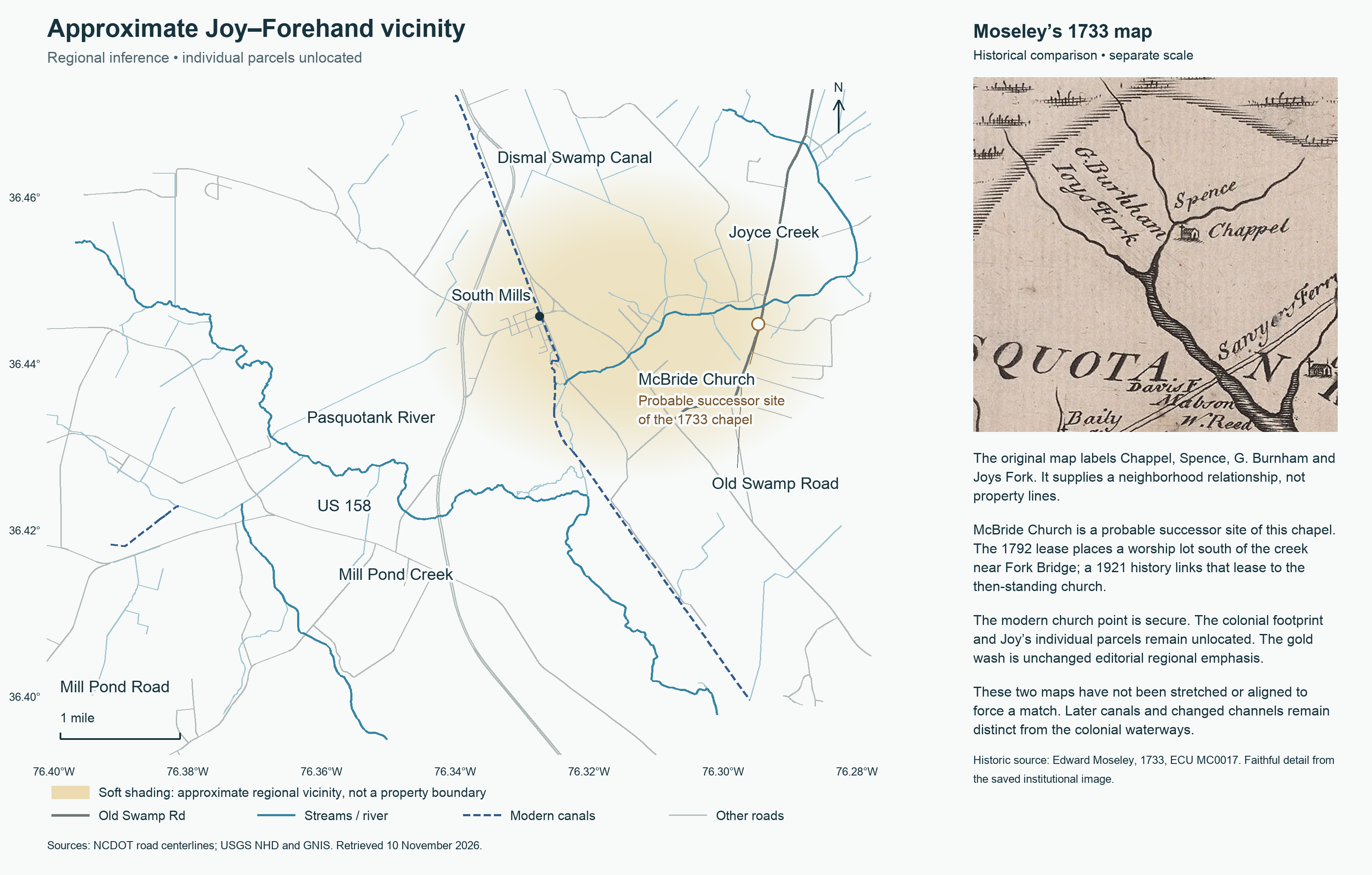
Historic map: Edward Moseley, A New and Correct Map of the Province of North Carolina (1733), East Carolina Manuscript Collection MC 0017, East Carolina University Libraries, catalog 1028. Modern road and waterway data: NCDOT and USGS. Editorial map prepared 10 November 2026.
The creek called Joyce Creek today gives a modern point of approach. Jesse Forbes Pugh, writing in the 1950s, explained its name as a survival of Joy’s Creek. The North Carolina Gazetteer identifies it as probably Moseley’s Joys Fork, while warning that Moseley misplaced the tributary. Together, maps and deeds bring us into the South Mills and lower Joyce Creek vicinity. They do not bring us to Joy’s door.23
An earlier document places a William Joy in the practical business of the Pasquotank River. On 2 January 1704/5, a man of that name, described as a Pasquotank planter, undertook to pay five pounds in good fresh pork at Mr. John Jennings’s landing. Thomas Peterson acted for the New Pensilvania Company. The name and place strongly suggest the later landowner, although the document does not explicitly connect the two.4
Here the river was more than a boundary in a deed: its landing was the appointed place for settling an obligation. The five pounds meant a monetary value payable in pork, not five pounds of meat. A related pleading alleged that the obligation had been withheld and asked for judgment; the surviving image does not disclose the outcome. Nor does the company’s name take Joy back to Pennsylvania. The document places him in Pasquotank, already described as a planter, with an obligation to be met at a named landing.4
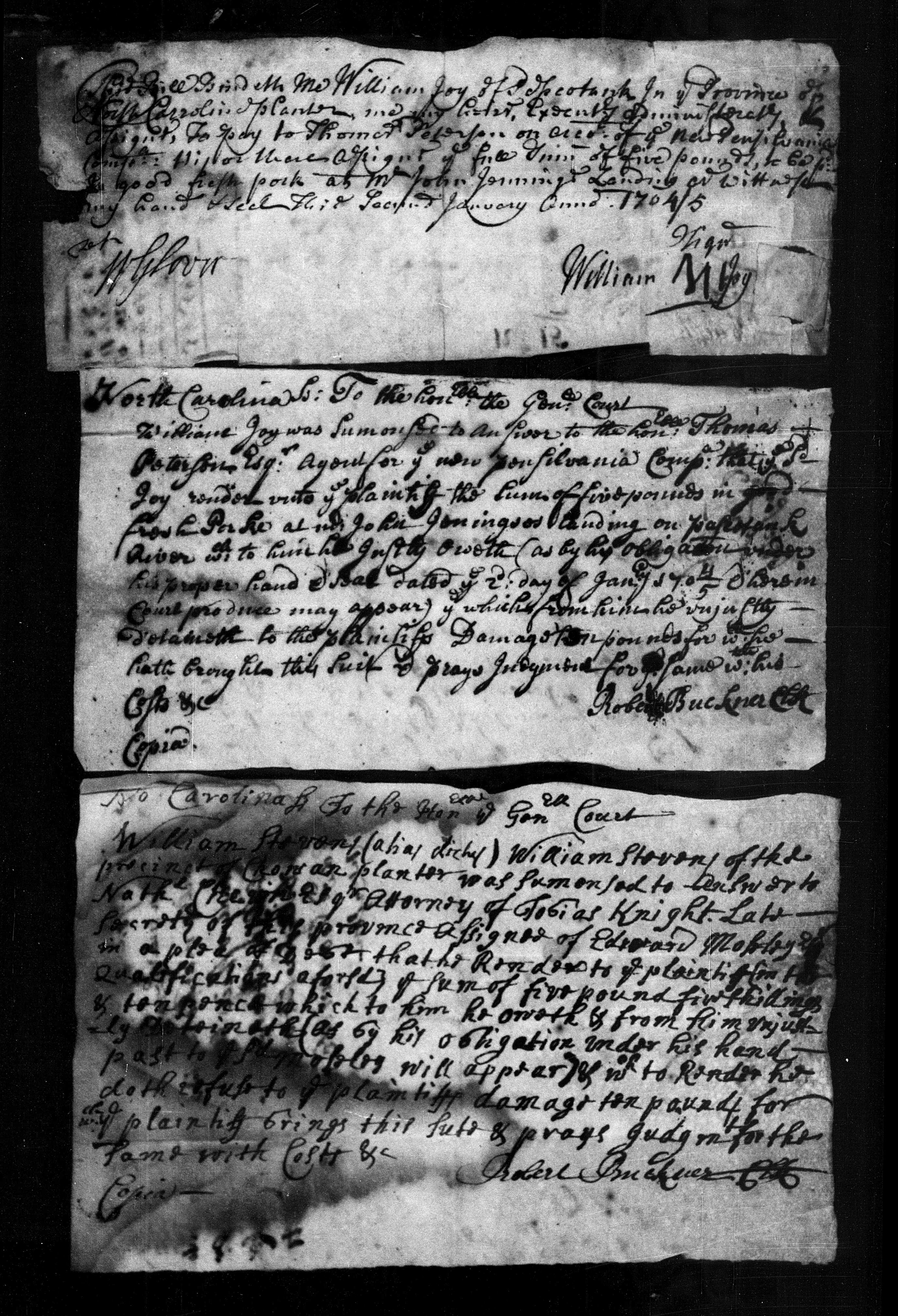
General Court obligation and pleading, FamilySearch group Chowan Court Records 1696–1712, DGS 7639571, image 339 of 498; document itself identifies Pasquotank.
By January 1711/12, another transaction supplies a plainer statement of residence. John and Mary Bishop conveyed 640 acres to Griffith Jones on the northeast side of the Pasquotank River, “up in the Fork Where Wm Joy lives.” Joy was neither seller nor buyer in that deed. The deed used his residence to identify the area being conveyed. The clause locates his residence without making him owner of the Bishops’ entire tract.5
Other records show land passing out of his hands before Cornelius’s purchase. A deed made in April 1713 describes Jeremiah Everton’s sale to Griffith Jones of the western two hundred acres of a four-hundred-acre tract bought from Joy. It refers to an assigned draft dated in July 1708; the surviving copy leaves the day disputed between the twentieth and thirtieth. A patent issued to James Spence in December 1716 repeats the succession from Joy through Everton and Jones to Spence. Thus a portion of Joy’s land can be followed through several owners, even though the original assigned draft has not been recovered.6
The oldest landholding reported for him comes from a later dispute. In November 1718, Captain James Browne told the Council that Joy had taken up 216 acres about twenty years earlier, then sold it to Nickolas Algate. Browne complained that neither man had seated the land as required, and his petition for the lapsed tract was granted. This points back to about 1698, but through Browne’s retrospective account. It gives Joy an earlier place in Pasquotank’s land history, not a place of birth.7
On the same April day in 1714 that he conveyed land to Cornelius, Joy made two other sales. William Phillips acquired a hundred acres for four pounds, described in the Fork and adjoining Gabriel Burnham. Joseph Monck acquired 364 acres at Poplar Tables, at the head of the Pasquotank. These were separate transactions with different descriptions. Cornelius’s deed remains particularly valuable because it places his purchase eastward of Joy’s dwelling plantation. William Norris and Jeremiah Everton witnessed it; the following day Joy acknowledged it in court.18
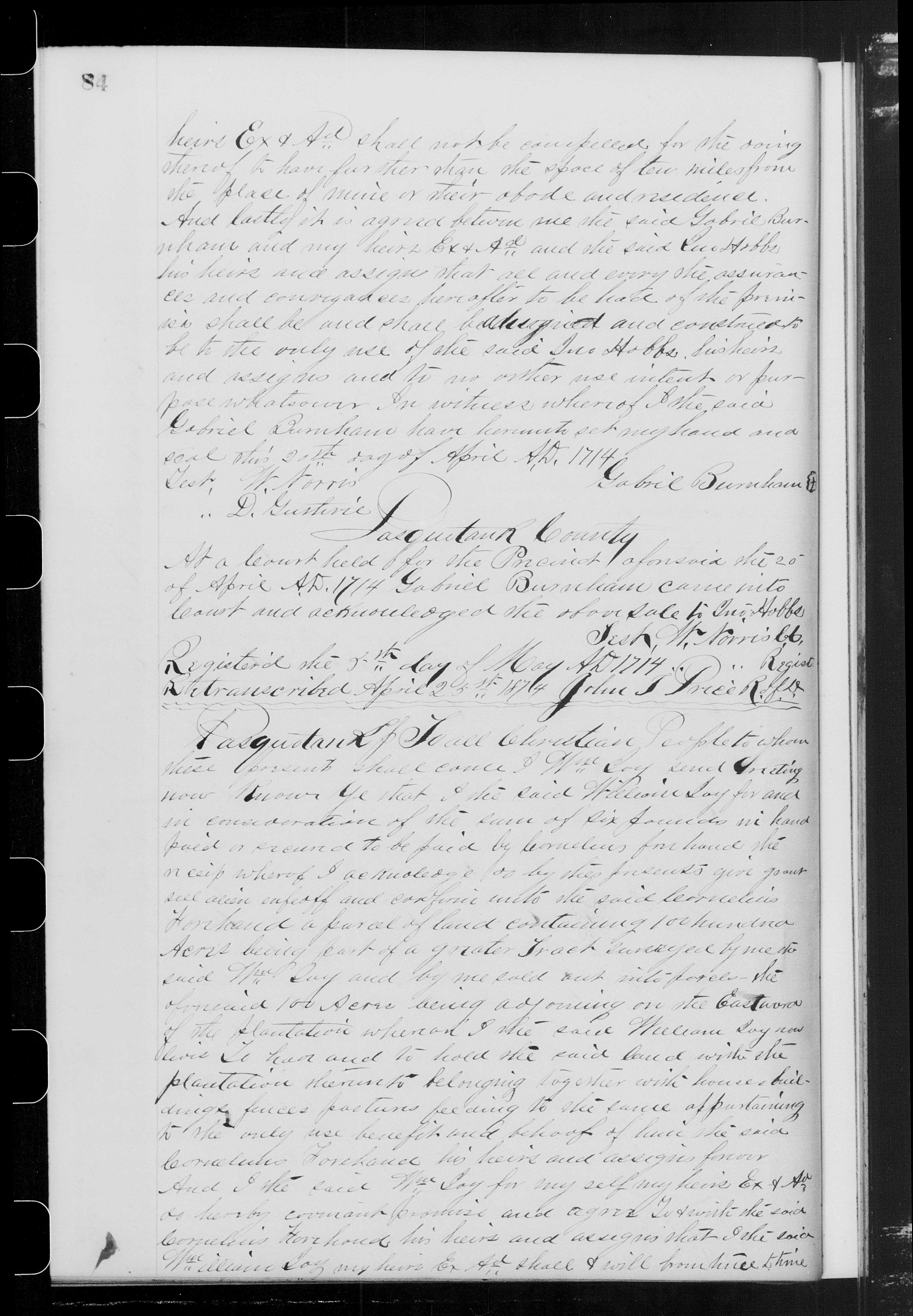
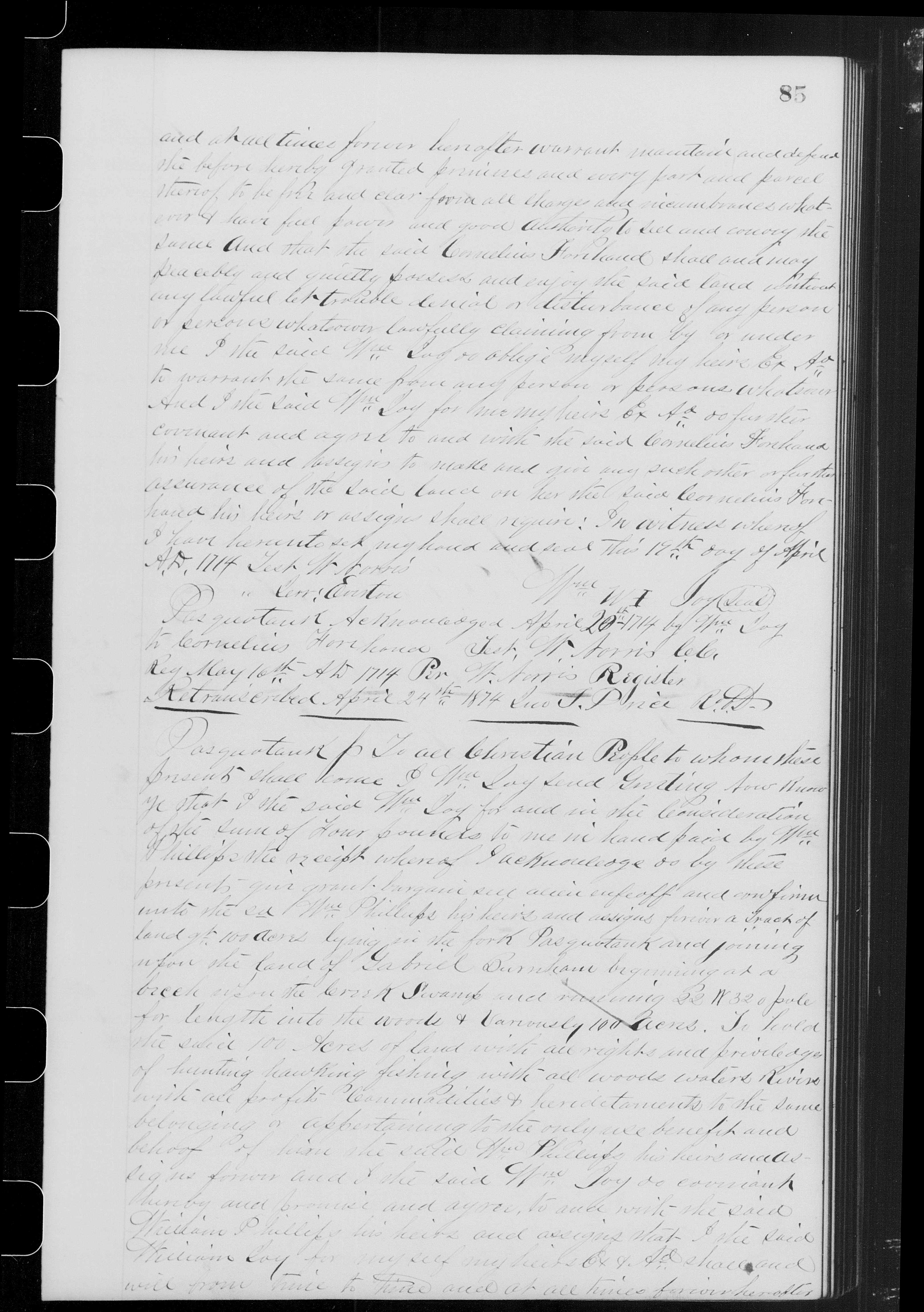
Pasquotank Deeds 1700–1747, copied pp.84–85; FamilySearch DGS 7517567, images 87–88. Historical grantor index: oldA:77.
There was a further hundred-acre conveyance to Cornelius in October 1718. This time the deed referred to a patent issued to Joy on 16 October 1716. Two later copies disagree on whether the conveyance was made on 20 or 21 October, and their boundary wording also differs. Until the titles can be reconciled, the two deeds for a hundred acres cannot simply be added together as two separate Forehand holdings. The later instrument may concern land that overlapped the earlier purchase.9
Joy also assigned his interest in a patent to James Jones on 21 October 1718 for twenty pounds. That same day Jones conveyed eighty acres to Henry Bright from land derived from Joy’s assignment. The surviving papers show a man whose name became part of several other owners’ titles. They do not provide a single plan on which all his holdings can be fitted.10
A published tax account received on 25 March 1719 lists William Joy with one tithable and six hundred acres. Later that year a more personal entry may concern him. An October return asks relief from the levy for a William whose surname appears to be Joye, but is not securely legible. The man was said to be seventy or more, blind and disabled. If he was the landowner, he had been born by about 1649. The description is clear; the identification remains uncertain, and the entry records a request for relief, not proof that relief was granted.11
The last securely dated act in Joy’s own name is his will of 17 December 1725. He named Margery as his wife and sole executrix, leaving her what remained after his debts and stated bequest. Solomon Everton and Sarah Everton were to receive two hundred acres that he said he had already acknowledged to them in the Pasquotank precinct court. Jeremiah and Hana, or Hannah, Everton witnessed the will. The earlier acknowledgment has not yet been found, so the will preserves a land arrangement whose beginnings remain outside the recovered record.12
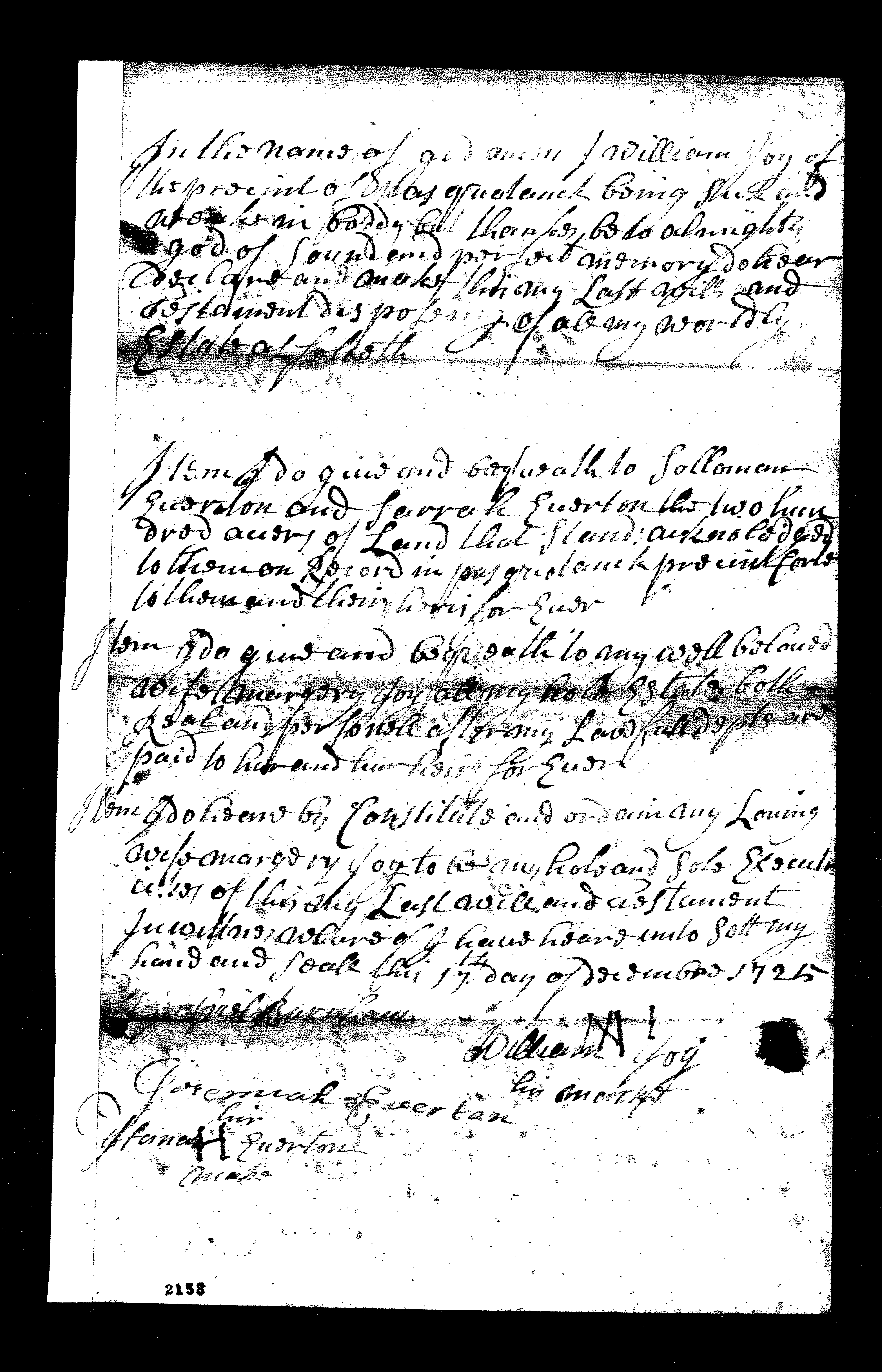
William Joy will, Pasquotank Precinct, 17 December 1725; proof 18 January 1725 as written and executrix oath 22 January 1725/6. Preserved family-collection scans of the original record; archival locator unverified.
Joy died on or after the day he made that will and by its court proof on 18 January 1725/6. Four days later Margery took her executrix’s oath before Gabriel Burnham. Those January endorsements establish the close of William’s life and the beginning of her documented responsibility for his estate. They do not supply an exact day of death.12
Margery appears again in a substantial conveyance of her own. On 23 August 1732, she sold Gabriel Burnham two hundred acres for fifty-five pounds, reserving its enjoyment during her lifetime. The land was part of William Joy’s 640-acre patent of 16 October 1716. Its bounds began at a beech beside a creek and reached James Forehand’s line. The terms postponed Burnham’s enjoyment until after her death; the recorded transaction therefore preserved something for Margery while arranging the land’s later possession.13
That deed was registered on 1 June 1733, the year of Moseley’s map. The map’s G. Burnham is probably Gabriel, whose name appears beside Joy-derived land in the deeds. Nearby stood the chapel symbol. McBride Church, on Old Swamp Road, is a probable successor site of that colonial chapel: a 1792 lease, an 1896 land description and a 1921 church history support the later site’s continuity. Pugh himself called the earlier chapel identification “quite probably.” It is a useful landmark for understanding the neighborhood, with no proved connection to Joy’s house or a particular Joy parcel.21314
What survives of William Joy is unusually attached to place. A landing appears in his obligation; the Fork identifies where he lived; his dwelling plantation helps describe Cornelius’s purchase. Margery’s deed carries the story onward to Burnham and James Forehand, while the map preserves the name Joys Fork. His beginning remains beyond the recovered papers. The ground on which his life crossed the Forehands’ is much better known: a hundred acres, eastward of the place where he lived.1
Family Ties
William’s wife Margery is explicitly named in his will. Her birth, maiden name, marriage date and death date are unknown; her own deed establishes that she was living in 1732. No parents, siblings or children of William have been established from the records examined. The people named as beneficiaries and witnesses in his will belong in the account of his life, but their appearance there alone does not establish a family relationship.1213
Between the Lines
Possibilities, not proven relationships.
How much farther back can this William Joy be followed? At a Perquimans court session printed under the date 1693 [1694], the court ordered payment to a William Joy for attendance and travel. Abstracts of a 1703 will also name William Joy and a woman written as Margre or Margare Joy as witnesses. These may extend the same man’s history, but the first entry gives too little identifying information and the will abstracts disagree. The original will and fuller court papers could strengthen or separate those identities. Neither lead presently supplies his origin.1516
Was he the William Joy named with Daniel McCoy in a 1720 patent? A 1751 deed recites a joint patent for 637 acres dated 1 April 1720. That is a plausible connection, still awaiting the patent and intervening title. The later deed’s Norfolk residents do not make Joy a former Virginian, and its 637 acres must remain separate from the 640-acre patent recited in Margery’s deed.17
A Life in the Records
This chronology distinguishes Joy’s acts from later references to his land, and secure readings from possible identifications. It covers the evidence currently identified, not every record that may survive. January dates written with two years retain the old-style dating used in the documents.
Dated acts and residence records
- 2 January 1704/5 — William Joy, Pasquotank planter, undertook to pay £5 in fresh pork at John Jennings’s landing. Probably the later landowner; the related pleading’s filing date and outcome are unknown.4
- 15 January 1711/12 — Bishop–Jones deed locates Joy “up in the Fork.” Executed and acknowledged that day; the later copy gives registration on 17 April with the same unusual 1711/12 year notation.5
- 19 April 1714 — Three deeds: 100 acres to Cornelius Forehand for £6; 100 acres to William Phillips for £4; 364 acres at Poplar Tables to Joseph Monck, preferred price reading £9. Acknowledged 20 April; registered 6 May. These are separate descriptions, not a reconstructed single holding.18
- 20 or 21 October 1718 — Hundred-acre conveyance to Cornelius, acknowledged 21 October. The 1816 copy gives execution 20 October and registration 23 October; the 1874 copy gives 21 and 25 October; the county index gives registration 25 November. Its relationship to the 1714 hundred acres remains unresolved.9
- 21 October 1718 — Joy assigns his patent interest to James Jones for £20; acreage and patent date unstated. Jones conveys eighty acres to Henry Bright the same day. The county index dates recording of Joy’s assignment 19 November, not a further act by Joy.10
- 17 December 1725 — Will names Margery as wife and executrix, and Solomon and Sarah Everton as joint beneficiaries of two hundred acres already acknowledged to them. Jeremiah and Hana/Hannah Everton witness.12
Earlier acts recited in later records
- About 1698; sale before November 1718 — Browne’s 11 November 1718 petition says Joy took up 216 acres about twenty years earlier and afterward sold them to Nickolas Algate. Neither original transaction has been recovered.7
- [20/30] July 1708 — Date attached to Joy’s assigned draft in the 1713 Everton–Jones deed; the day remains disputed. The deed describes four hundred acres bought from Joy, with the western two hundred conveyed onward. Joy’s original survey and separate sale dates remain unknown.6
- 16 October 1716 — Patent date recited in later Forehand and Margery deeds; Margery’s instrument supplies the 640-acre parent acreage. The patent itself remains unrecovered.913
- 1 April 1720 — William Joy and Daniel McCoy’s 637-acre patent, recited in a 1751 conveyance. The original patent and identification of this Joy remain unresolved.17
- Before 17 December 1725 — Joy’s will refers to an earlier court acknowledgment of two hundred acres to Solomon and Sarah Everton. Its precise date and original entry remain unknown.12
Earlier candidates, tax accounts and reported leads
- 6–9 November 1693 [1694] — Published Perquimans court record orders payment to Wm Joy for attendance and travel. The printed date problem remains, and this man has not been securely identified with the later landowner.15
- 30 October 1703; proof 14 or 17 April 1704 — Conflicting Boferdt/Botnett will abstracts name William Joy and Margre/Margare Joy as witnesses. The original will remains unread; the proof days are competing readings of apparently one record.16
- 1714, reported — A local account mentions a Patrick Kelly upper-quarter transaction. Unverified; the recovered April hundred-acre deed names William Phillips.20
- 1715, attributed — Two dependent local tithables transcriptions list William Joy with one taxable. The assigned year has not been verified against an original; these are not two independent appearances.1120
- Undated, published as circa 1716 — A corn list names Will: Joy, followed by Jos: Monk. The date is editorial, and the amounts are corn, not numbers of taxable people.18
- 1717, reported — Pugh dates Joy’s blindness to this year. No separate contemporary 1717 record has been recovered.3
- 25 March 1719, including 1718 — Date an account was received: its published transcription lists Wm Joy, one tithable, six hundred acres. This is an account date, not proof of personal attendance or necessarily a fresh 1719 assessment.11
- October 1719 — Original tax-sheet scan: William Joye [?], seventy or more, blind and disabled, petitions for levy relief. Surname and exact day remain uncertain; birth by about 1649 follows only if he is this William Joy.11
Two proposed beginnings should not become life dates: Pugh’s estimated birth about 1670 lacks supporting contemporary evidence, and a 1 August 1652 Virginia headright is abstracted as William Foy or Joy, with the inspected register crop favoring Foy. Neither establishes Joy’s birth or immigration. No verified militia appearance has been identified for this William Joy.322
Continuing title history, estate proceedings and the place name
These dates record other people’s acts or later references, rather than additional appearances by William.
- 21 April 1713; registered 22 July — Jeremiah Everton’s conveyance to Griffith Jones of the western two hundred acres bought from Joy. Hannah, identified as Everton’s wife, joins the acknowledgment. The surviving copy’s inconsistent given names are retained as a source problem.6
- 20 December 1716 — James Spence’s two-hundred-acre patent recites the Joy → Jeremiah Everton → Griffith Jones → Spence chain. It is distinct from Joy’s recited October patent.6
- 11 November 1718 — Council grants Browne’s lapse petition concerning the Joy–Algate 216 acres.7
- 30 March 1719 — James Brown receives 216 acres at the head of Pasquotank, called the Quarter or Allgoods. A strong candidate for the lapse tract, but the patent does not name Joy or Algate.19
- 18 January 1725 as written, read in sequence as 1725/6 — Joy’s will is proved. He died on or after 17 December 1725 and by this proof date.12
- 22 January 1725/6 — Margery takes the executrix’s oath before Gabriel Burnham. This is not William’s death date.12
- 23 August 1732; acknowledgment 8 October, preferred reading; registered 1 June 1733 — Margery conveys two hundred acres to Gabriel Burnham for £55, reserving lifetime enjoyment. The later registration does not establish that she was still alive in June 1733.13
- 1732–1733, reported — Accounts of Margery’s Virginia residence and Sykes dealings remain unverified. A John Linton power of attorney is indexed as recorded 1 June 1733, old C:329; the underlying instrument has not been inspected.20
- 1733 — Moseley’s map labels Joys Fork, G. Burnham, Spence and Chappel. These are place references, not evidence that Joy was living.2
- 10 April and 9 October 1739 — James Forehand assigns land under the 1714 title to Richard Fothergale; Fothergale’s October deed conveys fifty acres to Benjamin Burnham in the fork of Pasquotank. October court proof and 13 October registration follow.21
- 30 October 1750; April court and 18 April 1751 registration — Cornelius Forehand conveys Caleb Burnham fifty acres in the Fork, part of a Joy patent whose date is unstated. Identification of this Cornelius as the original buyer’s son is inferred.21
- 15 June 1751; October court and registration — Samuel McCoy conveys Daniel McCoy 168 acres from the recited 1720 Joy–McCoy patent. The October registration day is blank; the surviving copy was made 20 January 1825.17
- 1808; 1953; 1957 — Price–Strother’s map uses Joy C; Pugh’s two histories associate the modern creek name with William Joy. These preserve cartographic forms and later historical interpretation.23
The Family as We Currently Understand It
The surviving will documents William and Margery as husband and wife. No child connection is shown.
Birth date and birthplace unknown
Died between 17 December 1725 and 18 January 1725/6, inclusive
Birth surname and birth date unknown
Living on 23 August 1732
Death date unknown
Documented marriage
William’s will of 17 December 1725 names Margery as his wife and executrix.
The solid line denotes the documented marriage. Unknown dates remain open; probate and registration dates are not treated as dates of death.
Sources
- William Joy to Cornelius Forehand, 19 April 1714; acknowledged 20 April, registered 6 May. Pasquotank deeds, old A:77; surviving 1874 copy, pp. 84–85, FamilySearch DGS 7517567, images 87–88. Opening and continuation.
- Edward Moseley, A New and Correct Map of the Province of North Carolina (1733), East Carolina University, MC0017, upper Pasquotank detail; original map image. ECU map record. “Joyce Creek,” North Carolina Gazetteer, NCpedia, identifies the creek provisionally and notes Moseley’s displacement. Also Jonathan Price and John Strother, map of North Carolina dedicated to David Stone and Peter Brown (Philadelphia: C. P. Harrison, 1808), Library of Congress, G3900 1808 .P7, resource g3900.ct003493; Library of Congress map record. Its upper-river label reads Joy C.
- Jesse Forbes Pugh, Three Hundred Years Along the Pasquotank: A Biographical History of Camden County (1957), pp. 24–25, 36; ECU digital edition. Also Pugh, Journeys Through Camden County (1953), p. 14. These are later historical interpretations, distinguished here from contemporary deeds and maps.
- William Joy obligation, 2 January 1704/5, and associated pleading, FamilySearch DGS 7639571, image 339; original-record image. Catalogued with Chowan court records, 1696–1712; the document itself identifies Joy as of Pasquotank.
- John and Mary Bishop to Griffith Jones, 15 January 1711/12, Pasquotank deeds, surviving 1874 copy, pp. 31–32, DGS 7517567, images 34–35. Opening and continuation. The residence clause does not establish Joy’s ownership of these 640 acres.
- Jeremiah Everton to Griffith Jones, 21 April 1713, old A:47; surviving 1874 copy, pp. 51–52, DGS 7517567, images 54–55. Opening and continuation. James Spence patent, 20 December 1716, 200 acres, Patent Book 111-B:123, file 127, recorded patent image. Everton is the normalized prose spelling; the 1713 copy has Everington, the patent Everinton. The copy also contains an inconsistent given name. The July 1708 day is disputed, 20/30.
- Council minutes, 11 November 1718, James Browne petition; Colonial Records of North Carolina, II:314, 318, published transcription. The earlier acquisition and sale are retrospectively reported.
- Joy to William Phillips, 19 April 1714, surviving copy pp. 85–86, DGS 7517567, images 88–89, opening; Joy to Joseph Monck, same date, pp. 86–87, images 89–90, opening and continuation. Both acknowledged 20 April and registered 6 May; inspected images are 1874 copies.
- Joy to Cornelius Forehand, October 1718, two inspected historical copies: copied 29 September 1816, execution 20 October and registration 23 October; copied 23 May 1874, execution 21 October and registration 25 October, p. 199, DGS 7517567, image 202, record image. Both give acknowledgment 21 October. The county index instead gives 25 November registration.
- Joy to James Jones and Jones to Henry Bright, 21 October 1718, surviving 1874 copies, pp. 198–199, DGS 7517567, images 201–202. Bright deed, Joy assignment. The assignment’s acreage is unstated. The county index gives its recording as 19 November 1718.
- Raymond A. Winslow Jr., “Pasquotank Co., N.C., Tax List 1719,” North Carolina Genealogical Society Journal 25(1), February 1999, pp. 3–13, especially p. 9: published transcription of Edmund Gale’s account received 25 March 1719, including 1718. Separately, October 1719 northeastern Pasquotank tithables return, preserved original-record scan in the Forehand research collection: William Joye [?] age and disability petition, surname and exact day unresolved. No verified institutional image number is supplied for that scan.
- William Joy, original will dated 17 December 1725, with court proof dated 18 January 1725 as written and executrix’s oath 22 January 1725/6; Pasquotank, North Carolina. Both original-record scans are preserved in the Forehand research collection; their right edges are partly clipped. The January sequence is expressed here as 1725/6 to distinguish the old-style year from the modern year. No newly verified institutional image number is supplied. Preserved will scan and endorsements.
- Margery Joy to Gabriel Burnham, 23 August 1732; acknowledgment 8 October 1732, preferred reading; registered 1 June 1733; copied 7 July 1823. Pasquotank C:327–328, DGS 7517572, images 353–354. Opening and continuation.
- Pugh, Journeys (1953), p. 14, and Three Hundred Years (1957), p. 120; Jeremiah Sexton’s lease, 14 November 1792, Camden F:79, DGS 7513202, image 58, register image; “Land Sale,” Economist, 19 June 1896, p. 2, DigitalNC; Rev. R. H. Willis, “Beginnings of Methodism in the Elizabeth City District,” Independent, 20 May 1921, p. 1, DigitalNC. Modern site: NCDOT R-5717 historic-architecture survey (February 2018), pp. 116–118, 124–125, official report. These sources support later continuity and a probable earlier identification, not an exact 1733 footprint or Joy title.
- Perquimans court, November 1693 [1694], Colonial Records, I:399–404, especially p. 402; published transcription. The heading’s bracketed date is retained; identity with the later William Joy remains provisional.
- J. R. B. Hathaway, North Carolina Historical and Genealogical Register I(2), April 1900, p. 184, John Boferdt will, 30 October 1703, proved 14 April 1704; J. Bryan Grimes, Abstract of North Carolina Wills, p. 41, John Botnett, proof 17 April 1704, public abstract transcription. These are conflicting abstracts; the original will was not recovered.
- Samuel McCoy to Daniel McCoy, 15 June 1751, Pasquotank C:50, DGS 7517572, image 53, record image, copied 20 January 1825. Recites William Joy and Daniel McCoy’s 637-acre patent, 1 April 1720. Identity with the subject is plausible, not proved by the recital alone.
- Raymond A. Winslow Jr., “North Carolina Corn List Circa 1716,” North Carolina Genealogical Society Journal XII(4), November 1986, pp. 213–219, Joy and Monk at p. 217. Published transcription; source identified as Corn Lists, No Dates, 1715–1716, CCR 190, Taxes and Accounts, 1679–1754. The original is undated.
- James Brown patent, 216 acres, 30 March 1719, North Carolina Patent Book 1:272, file 308, record image. Connection to the 1718 lapse proceeding remains inferred.
- Preserved Forehand family research notes and dependent tithables transcriptions; Pugh’s historical accounts; Pasquotank grantor/grantee indexes, Joy section pp. 344–345, DGS 7517579, and Jeremiah Everton entries p. 372, DGS 7517611. These are reported leads and index references, distinguished from inspected underlying deeds. The Patrick Kelly, Virginia-residence and Sykes claims are not adopted as established facts.
- James Forehand to Richard Fothergale, 10 April 1739, Pasquotank B:264, DGS 7517571, image 269, register copy; Fothergale to Benjamin Burnham, 9 October 1739, B:286–287, images 291–292, opening and conclusion. Cornelius Forehand to Caleb Burnham, 30 October 1750, Pasquotank register copy dated 30 June 1819, preserved in the Forehand research collection; proof April court 1751, registration 18 April. No new institutional locator is supplied for that scan.
- Nell Marion Nugent, Cavaliers and Pioneers, I:259–260, Henry Fleet’s Lancaster County, Virginia, 200-acre patent, 1 August 1652, Patent Book 3:100. Abstract reads William Foy (or Joy); the inspected incomplete register image favors Foy. This is not evidence of the Pasquotank man’s arrival.