A road into Newland, a trading place called Joppa, and two bridges whose histories meet along the upper Pasquotank.
South of South Mills, the old road reaches water twice. Coming from the Camden side, it first encounters the straight channel of Turner’s Cut. Beyond that lies the winding natural Pasquotank River, where River Bridge once carried the road toward Newland. The canal crossing came later. When colonial travelers used River Bridge, there was no Turner’s Cut to cross.1
Steven Forehand’s marked route follows the Camden approach and then the old roadbed he identifies in the woods on the Pasquotank side, connecting roads that no longer meet. The two approximate crossing sites shown here combine his location knowledge with historic maps; they are guides to the landscape, not surveyed bridge foundations. The later canal crossing is remembered locally as Bingham Bridge.1
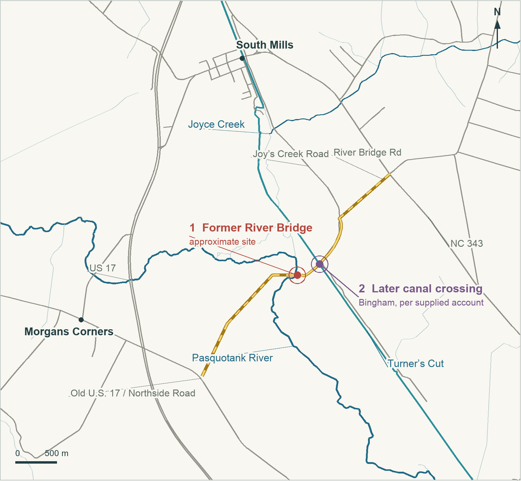
Project cartography, 12 November 2026, from NCDOT roads, USGS NHD/GNIS waterways and Steven Forehand’s annotated location; historical comparison with the 1915 engineer map and 1982 USGS map.
The road to River Bridge
George Washington came this way in May 1763. Traveling through the district his account called “newfoundland,” understood as Newland, he reached River Bridge and found a river about thirty yards wide, deep enough for vessels from New England to load there. Those thirty yards measured the water, not the bridge. The passage belongs to his investigation of the Dismal Swamp country, long before his presidency.2
Washington’s account brings road and shipping together at the same place. A traveler could cross the river where a vessel could take on cargo. Later records show other reasons to come. A Pasquotank tax list was headed at River Bridge on 14 September 1774. On Sunday, 15 December 1782, the Methodist preacher Jesse Lee found a large gathering there. Neither record identifies every person physically present, but together they show how readily the crossing served as a public destination.3
In 1802 Congress made Pasquotank River Bridge an endpoint on a post-road route from Jonesburg. A North Carolina law of the 1824 session sought to finish a road from Parkeville to River Bridge, a project begun under an 1813 act. The crossing thus appears in plans reaching beyond its immediate neighbors: toward the settled country west of the river and into the larger Virginia–Albemarle road network.4
Joppa beside the water
There was a town here, small enough for its land to pass through deeds by the acre. On 6 February 1805, Arthur Old conveyed Anthony Butler three acres near River Bridge described as “commonly called the Town of Joppa.” An earlier transaction between Arthur and Hollowell Old had reserved a jointly held quarter acre containing a new storehouse. These were places of business as well as pieces of land.5
The town had numbered lots. In 1808 Anthony Butler sold Thomas R. Butler lot number two as laid out in a “Plan or Mapp,” beside Charles Grice’s lot number one. That plan has not yet been recovered. A different map, attributed to Exum Newby Jr. and cataloged by the State Archives as made before December 1845, shows Joppa’s street grid beside River Bridge. Farther along Joys Creek it marks a warehouse, separate from the town grid.6
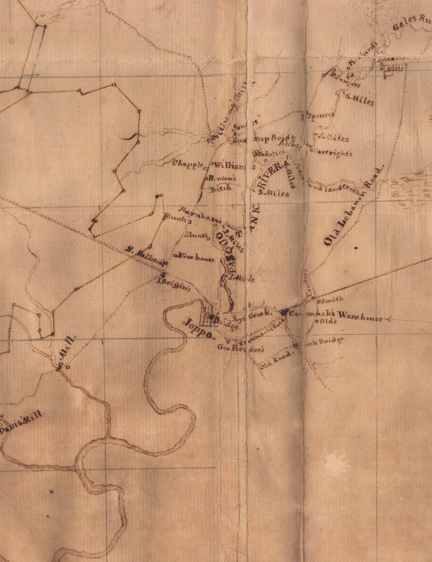
Joppa belongs in the history of the South Mills neighborhood, but its mapped grid stood by the natural-river crossing, south of the present village center on the canal. The name remained on an 1833 state map and in gazetteers published in 1836 and 1840. They record the continued use of the name, not the size of the settlement. Newby’s Old Lebanon Road and mill labels also place the crossing within the wider landscape explored in our Lemuel Forehand research, without assigning him ownership of a mill.6
The River Bridge Store papers bring the town’s business into view. A memorandum dated 12 January 1813, signed A. Butler, requests articles for the store: fish hooks, spectacles and cases, coffee mills, Carolina hoes, chocolate and tow cloth. The assortment reaches from field work to the table and the small conveniences of household life.7
Other papers record goods sent to River Bridge and commercial correspondence with George Ferebee. The A. Butler of the Elizabeth City correspondence can be identified with Anthony Butler, merchant and postmaster there, with High confidence. The evidence likewise supports Ferebee’s involvement in local store business. An invoice for the P.R.B. Store dated 6 February 1817 includes hoes, felling axes and shoes; other endorsements name New York and Baltimore. A May 1819 legal notice is more direct about the premises: it proposed taking depositions at George Ferebee’s storehouse at River Bridge.7
We can follow owners farther than we can place their buildings. A registered 1817 division gives Isaac Griffin and James Old separate shares of a road-fronting property associated with a storehouse. It is a useful candidate for the commercial premises, but no recovered lease or business record makes that identification certain. The historic lots cannot yet be outlined as modern warehouse footprints.8
The Old family’s inheritance dispute also concerned enslaved people and the income taken from their labor. They were central to the estate litigation even when the surviving papers treated them as property. The records do not place particular enslaved individuals at the River Bridge Store.8
A bridge made and broken in wartime
During the Civil War, a convenient crossing could become a military liability. In April 1862 Confederate instructions called for River Bridge to be destroyed if Union troops approached along the west side of the Pasquotank. The order was conditional; it does not establish that the destruction occurred. Clearer evidence comes from December 1863, when Edward A. Wild’s Union expedition moved through the South Mills country.9
By 12 December, Wild reported that his command had built a bridge below South Mills on old piles that were still standing but partly burned. His fuller report identified the waterway as the Pasquotank and credited Colonel Holman and Major Wright with construction, using material taken from a nearby Confederate captain’s house and barn. The captain was not named. Wild’s expedition included Black Union soldiers; Holman commanded the First United States Colored Troops. The report records the officers responsible for the construction without listing its individual laborers.10
The position below South Mills, the reused piles and a Confederate reference to the river bridge give High confidence that this was the historic River Bridge crossing. Wild’s men used it to reach Elizabeth City. By his report of 28 December, however, Confederates had destroyed the rebuilt bridge. Nearby military dispatches describe Confederate destruction of bridges and ferries while opposing his movements. Denying Union troops a crossing is the best-supported explanation; neither the precise demolition day nor the method is recorded. Earlier burning and this later destruction are two separate episodes.10
Nor was December 1863 necessarily the crossing’s final chapter. At its March Term in 1866, the Camden court regulated charges for “the Toll Bridge at the River Bridge.” A buggy, cart, or horse with saddle could pass and return for twenty-five cents. The stage and two-horse wagons paid a dollar for a return journey or fifty cents one way. The wording points to an active toll crossing after the war. But the clerk did not name the watercourse, and by then this road encountered both river and canal. The order does not settle which span was operating or when the natural-river bridge was finally abandoned.11
The canal and Bingham Bridge
Turner’s Cut had changed the route in the mid-1850s. By cutting through to the Pasquotank, the canal project bypassed part of the winding river and cut across an existing toll road. A drawbridge allowed road traffic to pass while leaving a passage for boats. This was the second crossing, a product of canal improvement rather than the colonial road’s original encounter with the river.12
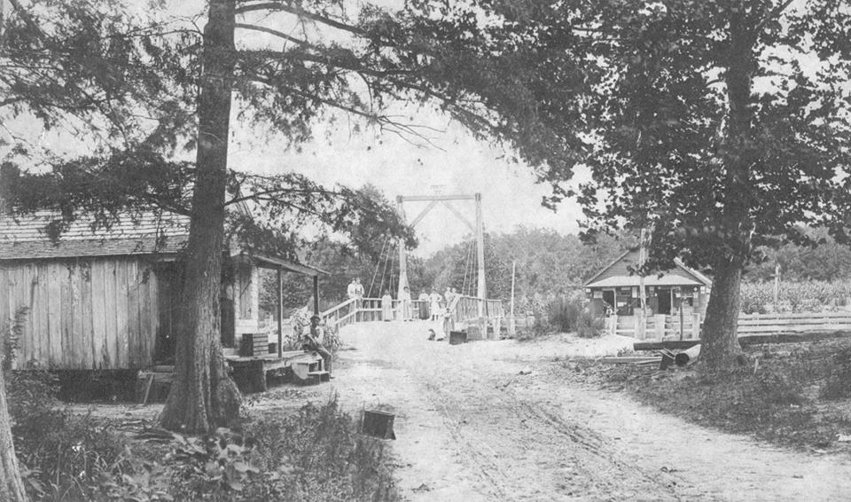
Two court cases preserve the most detailed history of the Turner’s Cut toll-road bridge. Their descriptions make it a strong candidate for the bridge remembered as Bingham, although neither opinion uses that name. The cases trace the road franchise to joint county action in 1847 and recount its passage from William R. Abbott to Thomas F. and Willis S. Grandy. In 1909 the road interest changed hands again. When maintenance failed, the later road owners tried to compel the Lake Drummond Canal Company to keep the bridge usable.12
The dispute exposed a practical division of interests: travelers needed a bridge over the canal, while boat operators needed an unobstructed channel beneath it. In September 1914 the North Carolina Supreme Court rejected the requested maintenance injunction. By 19 November 1915, when a federal court considered the remains, the bridge had decayed and gone down. An abutment and part of the structure extended into the water and endangered navigation. The government sought to make the canal company or the road owners remove them; the court dismissed that action against the defendants.12
These decisions document failure through decay and a dispute over responsibility, rather than destruction in battle. They do not record the day the bridge fell or the work that finally cleared it. Their accounts also conflict: the later opinion dates an earlier repair suit to 1912, while the 1914 account places the end of maintenance after an April 1913 event. The secure conclusion is that hazardous remnants existed by November 1915. A 1915 engineer’s map still labeled the separate natural-river site “Old River Bridge”; a surviving map label cannot tell us whether a bridge remained passable.13

By 1953, Jesse Forbes Pugh described the canal bridge as a former crossing. His directions continued beyond it to River Bridge over the Pasquotank, still joining the two sites by the old road.13
What the river kept
The Museum of the Albemarle exhibit carried the story below the waterline. Its interpretive panel reported more than 10,000 recovered artifacts, including 5,514 pieces of ceramics. Steven’s photographs preserve cases of tea wares, tankards, bottles, storage vessels and footwear. Some vessels have been assembled from broken pieces; the surviving shoes and leather components give the display a more personal scale.14
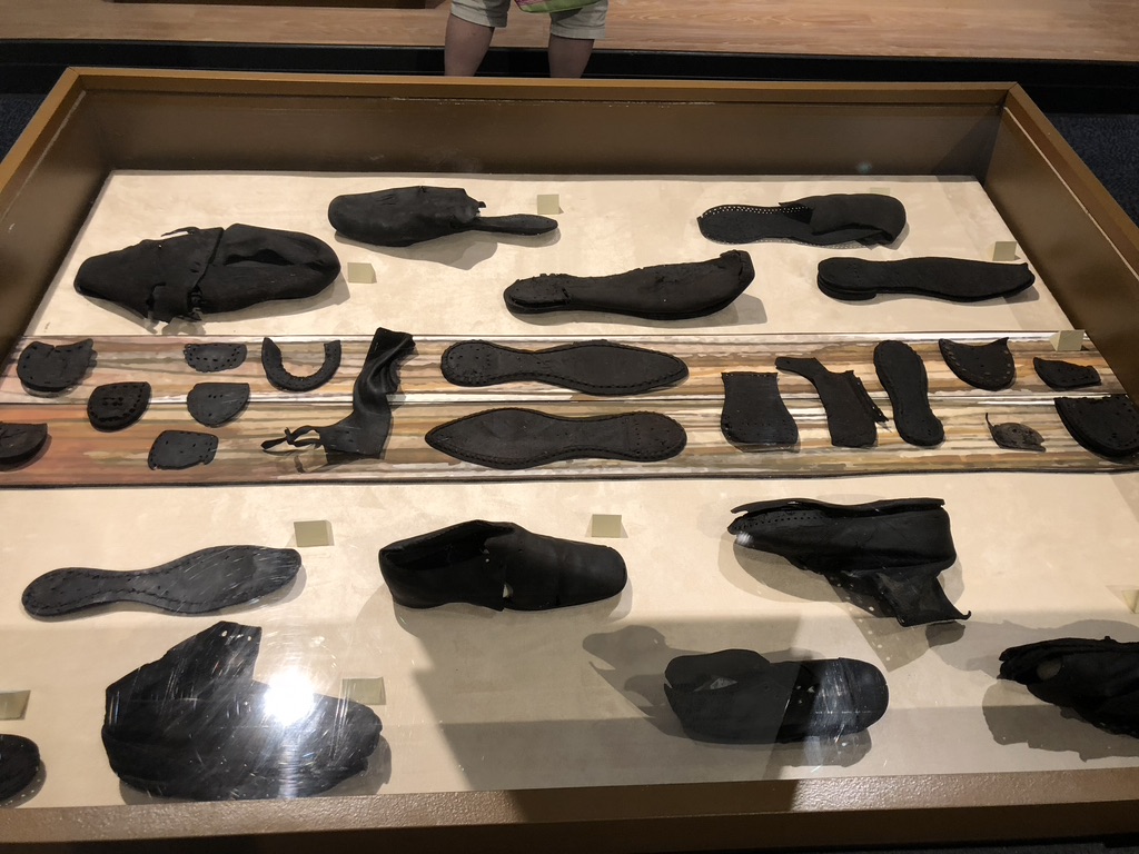
Photograph supplied by Steven Forehand; Museum of the Albemarle.
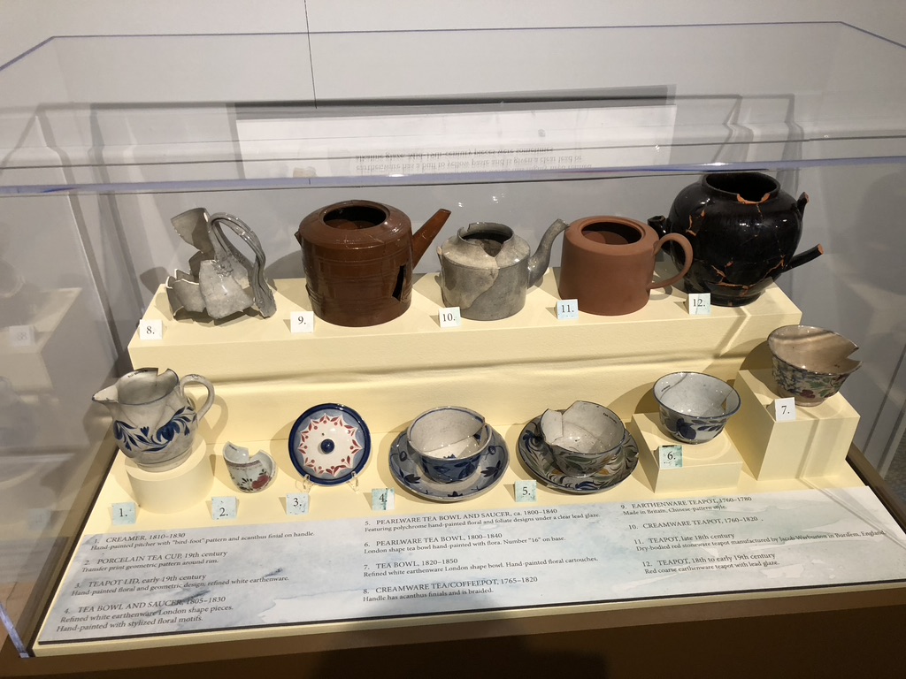
Photograph supplied by Steven Forehand; Museum of the Albemarle.
The exhibit’s dates range across generations. Its ceramic panel includes early wares and nineteenth-century vessels, while a baking-powder bottle in another case is labeled 1900–1910. That later object does not prove a bridge was standing then: an object’s manufacture, its arrival at the river and its deposition are different events. Without the excavation records and individual findspots, we cannot assign the displayed pieces to a named Forehand household, Butler’s stock list or Ferebee’s premises.14
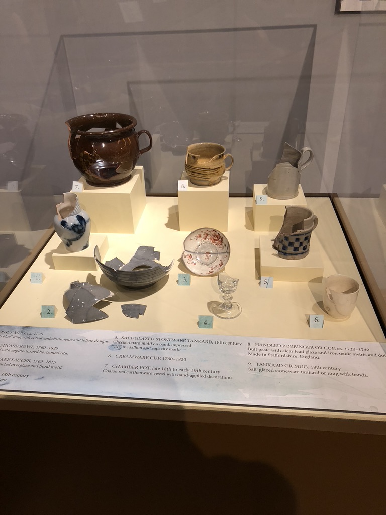
Photograph supplied by Steven Forehand; Museum of the Albemarle.
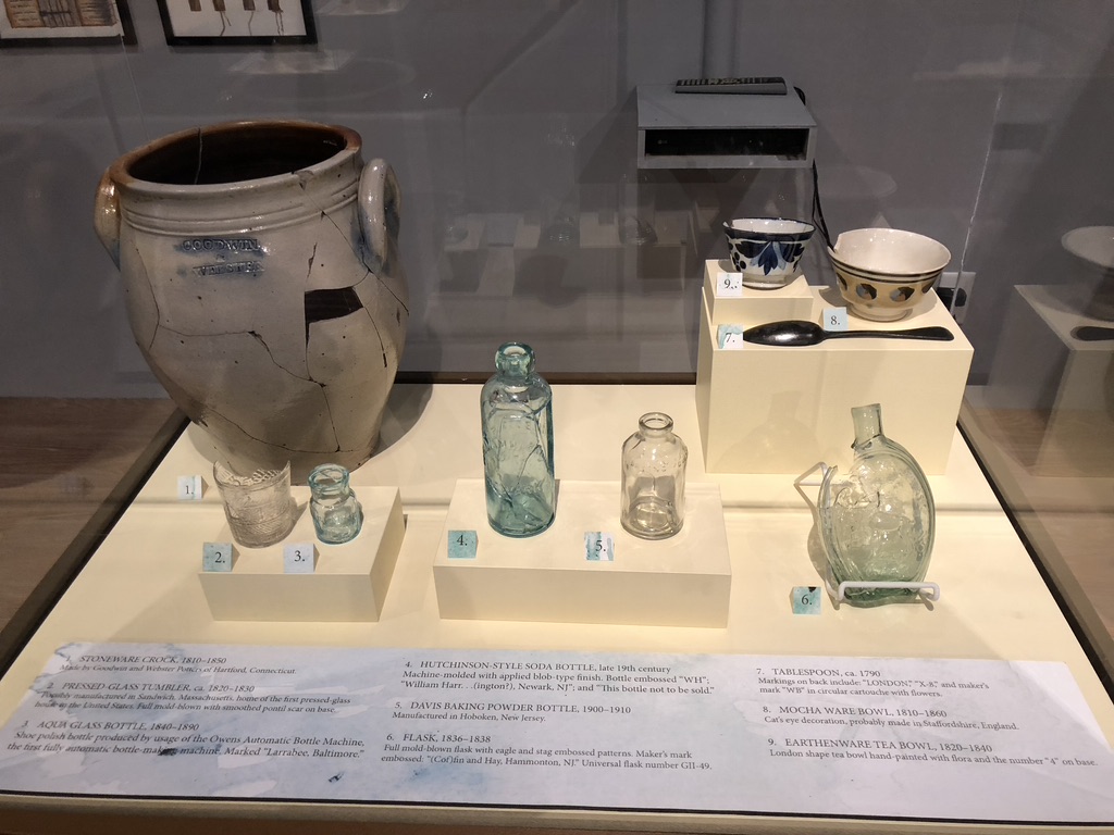
Photograph supplied by Steven Forehand; Museum of the Albemarle.
Yet the comparison is useful. The store papers name the articles people ordered; the exhibit preserves objects recovered from the place where such goods circulated. The road, the town grid and the remains brought up by divers give River Bridge a history larger than the timber structure alone. Bingham belongs beside it as the later crossing that the canal made necessary. On the modern map, the two gaps in the old road now have distinct stories—and Joppa has a place again on the Camden bank.
Sources and notes
- Steven Forehand, annotated modern satellite map supplied 12 November 2026; project georeference comparison, 12–15 November 2026. Approximate River Bridge site 36.4222, −76.3200; canal crossing 36.4234, −76.3170. Comparison includes Exum Newby map, State Archives MC.154.1845n, and the 1915 U.S. Engineer map in Upper Pasquotank River, N.C. (1916). These are approximate historical placements.
- Donald Jackson and Dorothy Twohig, editors, The Diaries of George Washington, volume 1, pp. 319, 322–326. The memorandum is headed 15 October 1763; the editors identify the described journey as May 1763. This is not the presidential tour of 1791. Scholarly edition inspected, not the handwritten manuscript.
- Pasquotank tax list, 14 September 1774, collection image “1774 Pasquotank 4.jpg”; Minton Thrift, Memoir of the Rev. Jesse Lee, with Extracts from His Journals (1823), pp. 42–48, especially p. 48. Printed page reads Sunday the 15th; tax-list heading does not prove every taxpayer attended there.
- Act of 3 May 1802, chapter 48, §2, 2 Stat. 190; Laws of North Carolina, 1824 session, chapter XXXVIII, pp. 42–43 (printed 1825). Authorization and completion provisions are not evidence that the road was finished in 1824.
- Camden County deeds: K:166, Hollowell Old to Arthur Old, 7 September 1803; K:463–464, Arthur Old to Anthony Butler, 6 February 1805. Original register images inspected; recorded copies of the transactions.
- Camden deeds M:114–115, Anthony Butler to Thomas R. Butler, 31 May 1808. State Archives of North Carolina, MC.154.1845n, map attributed to Exum Newby Jr., undated, cataloged prior to December 1845. Supporting name evidence: MacRae–Brazier map (1833), Mitchell’s gazetteer (1836), p. 74, and Chapin’s gazetteer (1840), p. 144. These printed references establish use of the name, not population. The Newby map’s mill locality corresponds with the western Horseshoe Road area at High confidence; no individual mill ownership follows.
- State Archives, Camden Miscellaneous Records, CR.018.928.003, “Records of the River Bridge Store, 1813”; FamilySearch DGS 104178636, images 249–296. Particularly 12 January 1813 memorandum, image 252, goods lists 250–251, shipments 263–264, correspondence 257–258 and 267–270, and 6 February 1817 invoice, image 294. The folder contains multiple dates. Anthony Butler identification also uses the 1816 federal postmaster list and postal signature. Joseph Overton estate notice, 1 May 1819, DGS 004969502, image 480, explicitly names Ferebee’s storehouse. Proposed depositions do not prove the session occurred.
- Camden deeds P:254 (1816) and P:323, 26 May 1817 Griffin–James Old division; same parcel at High confidence, identification with the Butler–Ferebee business remains Possible. Sawyer–Old equity bill, DGS 004969502, images 328–334, filed among Hollowell Old estate papers. The pleading’s allegations concern enslaved people and labor income; it is not a recovered judgment. Its endorsement and internal chronology conflict.
- Benjamin Huger report, 28 April 1862, concerning 19 April, Official Records of the Union and Confederate Armies, series I, volume IX, pp. 328–330 and accompanying map; original printed pages checked. The instruction to destroy River Bridge was conditional.
- Edward A. Wild, reports of 12 and 28 December 1863: Official Records, series I, volume XXIX, part II, p. 562, and part I, pp. 911–915, especially 911 and 914. Supporting dispatches: George W. Getty, 22 December, part II, p. 576; Joel R. Griffin, [December] 19, [1863], p. 883. The published reports reproduce contemporary correspondence. They do not establish an exact demolition date, unit or method, or permanent abandonment.
- Camden Court of Pleas and Quarter Sessions, March Term 1866, DGS 008673253, image 156, left page, first miscellaneous order; image 155 opens the term on 12 March. The toll order has no separately stated day or named watercourse.
- Hinton v. Lake Drummond Canal Co., 166 N.C. 484–488, filed 16 September 1914; United States v. Lake Drummond Canal & Water Co., 228 F. 66–70, decided 19 November 1915. Original printed opinions checked. Their nineteenth-century history is a judicial recital, not newly inspected underlying deeds. The 1915 opinion uses 1857 for the Cut; the later National Register history uses 1856. Neither opinion names Bingham. They also differ on one Hinton’s initials and maintenance history; the narrative does not resolve those discrepancies by assumption.
- Same opinions; Congressional Record, 2 March 1915, p. 5127, dates the government purchase of the competing Albemarle and Chesapeake Canal to 30 April 1913. U.S. Engineer map, 5 June 1915, published in Upper Pasquotank River, N.C. (1916). Jesse Forbes Pugh, Journeys Through Camden County (1953), p. 15, distinguishes the former canal bridge from the natural-river crossing. His retrospective account supplies no precise disappearance date.
- Museum of the Albemarle, River Bridge exhibit, ten photographs supplied by Steven Forehand, particularly the ceramics interpretive panel (U08), footwear (U01), tea wares (U06), and bottles/crock case (U10). The count and artifact dates are attributed to museum interpretation; no excavation inventory or individual findspot catalog has been recovered in this research. Photograph metadata suggests 16 June 2018 but does not independently authenticate the capture date.